
2019 Ardonia arrocane season
| 2019 Ardonia arrocane season | |
 Season summary map | |
| Seasonal boundaries | |
|---|---|
| First system formed | May 17, 2019 |
| Last system dissipated | Season ongoing |
| Strongest storm | |
| Name | Arlene (Strongest/most intense tropical cyclone ever recorded) |
| • Maximum winds | 180 mph (290 km/h) (1 minute sustained) |
| • Lowest pressure | 899 mbar (hPa; 26.55 inHg) |
| Seasonal statistics | |
| Total depressions | 7 |
| Total storms | 7 |
| Arrocanes | 4 |
| Major arrocanes (Cat. 3-5) |
2 |
| Total fatalities | 1,453 total |
| Total damage | $219 billion (2019 AC) |
| Related articles | |
|
| |
| Ardonia arrocane seasons 2019, 2020 | |
The 2019 Ardonia arrocane season is the ongoing annual period in which tropical cyclones—known regionally as arrocanes—form in the Ardonian Ocean and adjacent waters. The season officially began on May 15 and will end on October 31, dates which conventionally mark the period when arrocanes are most likely to develop across the region. The season is monitored by the National Arrocane Center (NAC) in Ataraxia, with local coordination provided by regional National Weather Service (NWS) offices across the continent.
So far, the season has featured the formation of seven named systems:
- Arrocane Arlene, a Category 5 cyclone and the strongest on record;
- Tropical Storm Beryl, a compact storm that remained offshore;
- Arrocane Camille, a high-end Category 2 landfalling storm;
- Tropical Storm Dennis, a minimal open-ocean system;
- Arrocane Erika, a Category 1 storm that remained over water; and
- Arrocane Florence, a Category 4 major arrocane that caused catastrophic impacts across western Ardonia.
Arlene caused unprecedented devastation across Cydonia and parts of southern Northwind, leaving over 1,300 dead and $158 billion in damages. Beryl remained over the open ocean but intensified rapidly into a strong tropical storm. Camille peaked at 100 mph and 973 mbar before striking Felden, killing 23 people and inflicting $16 billion in damage. Dennis stayed at sea and caused no reported damage or casualties.
Erika formed south of Blade Island and reached 80 mph and 982 mbar before curving eastward and becoming extratropical, tying for the eighth-strongest arrocane on record. Though it never made landfall, Erika produced dangerous surf and elevated marine hazards along nearby coastlines.
The most destructive storm after Arlene has been Arrocane Florence, a rapidly intensifying Category 4 storm that slammed into western Conchord with peak winds of 150 mph and a pressure of 925 mbar. Florence caused widespread destruction through West Port, Deeproot, Fort Braymin, and Oakendale, killing 51 people and causing $45 billion in damage. It is the second-costliest storm on record in the basin.
With all seven systems forming prior to the end of June, early-season activity has been well above average. Warm waters and favorable upper-level patterns, fueled by the ongoing positive phase of the Southern Trade Oscillation (STO), continue to support tropical development. The western Ardonian Ocean remains 3–6°C above average, especially in deep oceanic heat content, while the eastern half is relatively cooler—limiting storm intensification in that region. This temperature contrast explains the weaker intensities of storms like Beryl, Dennis, and Erika compared to the powerful western cyclones.
As the season nears its peak, officials are urging continued vigilance across both coastal and inland regions. With its high fatality count and rapidly rising damage total, the 2019 season is already on track to become one of the most extreme in recorded history—possibly surpassing even the infamous 1865 season.
Seasonal forecasts
| Source | Date | Named storm |
Arrocanes | Major arrocanes | |||
| Average (1865) | 13 | 5 | 3 | ||||
| Record high activity | 13 | 5 | 3 | ||||
| Record low activity | 13 | 5 | 3 | ||||
| NAC | March 31, 2019 | 16-20 | 8-11 | 3-6 | |||
| VW | May 16, 2019 | 17 | 10 | 5 | |||
| T1X | May 16, 2019 | 18 | 12 | 6 | |||
| NAHC | May 16, 2019 | 18-22 | 9-12 | 1-4 | |||
| EX | May 16, 2019 | 24 | 9 | 4 | |||
| NF | May 17, 2019 | 17-21 | 6-11 | 2-4 | |||
| ECT | May 17, 2019 | 20 | 10 | 4 | |||
| HDC | May 17, 2019 | 17 | 9 | 4 | |||
| HA | May 17, 2019 | 18 | 9 | 4 | |||
| NAC | May 19, 2019 | 21-24 | 13-17 | 5-8 | |||
| VOLT | May 20, 2019 | 18 | 9 | 3 | |||
| LA | May 21, 2019 | 14 | 7 | 3 | |||
| NAC | June 2, 2019 | 24-29 | 14-17 | 7-10 | |||
| Actual activity |
6 | 4 | 2 | ||||
Prior to the official start of the 2019 Arrocane season, multiple meteorological agencies across Ardonia issued forecasts anticipating a highly active year. The National Arrocane Center (NAC) released its first outlook on March 31, calling for 16 to 20 named storms, 8 to 11 arrocanes, and 3 to 6 major arrocanes. A revised outlook issued on May 19 significantly raised those numbers to 21 to 24 named storms, 13 to 17 arrocanes, and 5 to 8 major systems.
Forecasts from other meteorological organizations varied, but nearly all signaled an above-average or near-record season. Voltage/Jordinium (VOLT) and Viewer (VW) projected 18 and 17 named storms respectively, while T1xfed (T1X) predicted up to 12 full arrocanes and 6 majors. The North Alisean Hurricane Center (NAHC) issued one of the highest early forecasts, predicting 18 to 22 named storms and 9 to 12 arrocanes.
Several other forecasting agencies released their predictions in mid-May. Exile (EX) projected 24 named storms and 9 arrocanes, while Nevaeh (NF) anticipated 17 to 21 storms and 6 to 11 arrocanes, including up to four major systems. ECThunderstorms (ECT) and Hurricane Dave (HDC) each forecast 20 and 17 storms respectively, with 9 to 10 reaching arrocane status. HA Animations (HA) predicted 19 named storms and 10 arrocanes, highlighting the possibility of four or more major systems.
The surge in outlooks was attributed to persistently high sea surface temperatures across the Gulf of Ardonia and the ongoing positive phase of the Southern Trade Oscillation (STO), both of which are historically linked to hyperactive cyclone seasons. The NAC and several other agencies specifically warned of the potential for multiple Category 4 and 5 systems.
On June 2, 2019, the NAC released a third and more aggressive outlook, calling for 24 to 29 named storms, 14 to 17 arrocanes, and 7 to 10 major arrocanes—the most extreme forecast ever issued by the agency. The updated projection cited a concerning trend in long-range models, which pointed to a possible surge in storm development beginning in mid-June and extending into late July. According to the NAC, there is a heightened probability for multiple systems to reach major status in rapid succession.
As of early June, three named storms have formed: Arrocane Arlene, a catastrophic Category 5 system; Tropical Storm Beryl, a non-impactful but record-breaking storm over open water; and Arrocane Camille, a powerful Category 2 system that became the most intense storm at that classification and the fourth costliest arrocane on record. The season's early activity and the evolving forecasts have led NWS offices across Ardonia to issue elevated readiness bulletins, urging coastal populations to prepare for what may be the most destructive arrocane season on record.
LIVE outlook

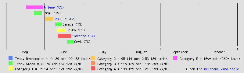
Seasonal timeline
Systems
Arrocane Arlene
| Category 5 arrocane (AAWS) | |
|---|---|
 | |
| Duration | May 17 – May 30 |
| Peak intensity | 180 mph (290 km/h) (1-min); 899 mbar (hPa) |
Arrocane Arlene was the first named storm of the season and the most powerful arrocane ever recorded in the Ardonia basin. Forming on May 17 over the central Gulf of Ardonia, Arlene underwent explosive intensification, reaching Category 5 strength just four days later with peak sustained winds of 180 mph (290 km/h) and a minimum central pressure of 899 mbar, both new basin records.
Arlene became the earliest Category 5 arrocane on record, and the first to make landfall at that intensity. On May 22, it made its first landfall in Po’Hatu, Cydonia with sustained winds of 175 mph and a pressure of 908 mbar, making it the most intense landfalling storm in Ardonian history. After briefly weakening, Arlene struck Meridian on May 23 at Category 4 strength (155 mph, 931 mbar), and made its final landfall in Port Kazu on May 25 as a Category 3 system (115 mph, 976 mbar).
Following its third landfall, Arlene stalled over Port Kazu for over 24 hours, unleashing catastrophic flooding and storm surge. It eventually drifted eastward, crossing into the Eastern Ardonian Ocean near Blade Island and transitioning to an extratropical cyclone before dissipating just northeast of the island on May 30.
Arlene broke a total of 15 records, including highest storm surge (50.75 ft), most rainfall from an arrocane (250.59 in), highest confirmed wave height (99.3 ft), and smallest observed eye (4.4 mi). It maintained Category 5 strength for 30 hours and underwent the fastest intensification on record, with a 24-hour increase of 70 mph in wind speed and a pressure drop of 69 mbar.
Arlene caused catastrophic damage across southern Ardonia, particularly in Po’Hatu, Meridian, Port Kazu, and coastal regions of Phaethon and Blade Island. It resulted in 1,379 confirmed deaths, over 15,000 injuries, and $158 billion in damages, making it the costliest and deadliest arrocane in Ardonian history.
Tropical Storm Beryl
| Tropical storm (AAWS) | |
|---|---|
  | |
| Duration | May 23 – May 29 |
| Peak intensity | 65 mph (105 km/h) (1-min); 989 mbar (hPa) |
Tropical Storm Beryl was the second named storm of the season, forming from a low-pressure system over the southeastern Ardonian Ocean on early on May 23. The system gradually organized and reached tropical storm strength by May 25, remaining entirely over open waters throughout its lifespan. Beryl peaked with sustained winds of 65 mph (105 km/h) and a minimum central pressure of 989 mbar on the early morning of May 26 before transitioning into an extratropical cyclone on May 27. It dissipated completely by May 28 at 2300 Ardonian time and by 0000 on May 29 in terms of Zulu time.
Although Beryl caused no damage or fatalities, it broke multiple historical records dating back to the Great Arrocane Year of 1865. It became the second strongest tropical storm on record for the basin by windspeed, surpassing all previous non-hurricane systems except Tropical Storm Ten of 1865 (70 mph). Beryl also entered the top 10 most intense arrocanes by pressure, ranking just behind Tropical Storm Eleven of 1865 (988 mbar) until June 3-4, when Arrocane Camille would knock Beryl off the top 10. according to the NAC/NWS. Despite its limited impact, Beryl’s meteorological significance earned it a place in some of the basin’s historical records.
The Ardonia Meteorological Organization (AMO) has listed the name Beryl as a 9% likelihood of retirement due to the historical records it broke. However, while it made a historical intensity in the basin, it wasn’t an impactful storm which will hinder its retirement likelihood. This could change later on, but it will remain unlikely. Due to the recent loss of it's 10th place in the most intense arrocanes list, it will likely be decreased.
Arrocane Camille
| Category 2 arrocane (AAWS) | |
|---|---|
  | |
| Duration | June 1 – June 7 |
| Peak intensity | 100 mph (160 km/h) (1-min); 973 mbar (hPa) |
Arrocane Camille was the third named storm and second arrocane of the season. It developed in the northeastern Ardonian Ocean on June 1 and steadily strengthened as it moved west-northwestward toward the continent. Camille peaked as a low-end Category 2 arrocane with sustained winds of 100 mph (161 km/h) and a minimum central pressure of 973 mbar. This made it the sixth-strongest arrocane by windspeed and the fifth-most intense by pressure on record in the Ardonia basin—just behind Category 2 Arrocane Eight (1865) and narrowly surpassing it by one millibar.
The storm made landfall in western Felden on June 6 as a Category 1 arrocane, bringing widespread rainfall, strong winds, and moderate storm surge. Areas affected included the Kawaiin Islands, Riverstead, Basalt Coast, Fort Zuka, and further inland through Ferndale, Mahoa Docks, and Felora. Notable impacts were also reported in Mount Tempus, Niika’s Treefort, Hamburville, and Thralkeld. Flooding and wind damage were extensive across Felden’s coastal and mountainous zones.
According to the final report from NAC/NWS Ferndale, Camille caused 23 confirmed fatalities, 52 injuries, and approximately $16 billion in damages—making it the second costliest storm in Ardonian history, only behind the earlier Arrocane Arlene. Camille weakened rapidly over land and dissipated over northern Felden on June 7 at 0600 UTC.
Tropical Storm Dennis
| Tropical storm (AAWS) | |
|---|---|
  | |
| Duration | June 9 – June 14 |
| Peak intensity | 50 mph (80 km/h) (1-min); 990 mbar (hPa) |
Tropical Storm Dennis was the fourth named storm of the 2019 Arrocane season. It developed from a broad tropical disturbance designated as 04A over the southeastern Ardonian Ocean on June 9. Initially disorganized, the system gradually gained structure as it tracked northwestward beneath a weak steering ridge. It was classified as a tropical depression late on June 10 and strengthened into Tropical Storm Dennis early the following day.
Dennis peaked on June 11 with sustained winds of 50 mph (85 km/h) and a minimum central pressure of 990 mbar. Despite maintaining a symmetrical shape with persistent convection, the storm was unable to strengthen further due to the presence of moderate wind shear and intermittent dry air intrusion from the north and west. Satellite imagery showed a moderately defined low-level center, with banding mainly displaced to the storm’s eastern flank.
The system began curving northward on June 12 and eventually turned northeastward while remaining over open ocean. Encountering cooler waters and increasingly hostile upper-level conditions, Dennis began to weaken, transitioning into a post-tropical system by June 13 and fully dissipating by June 14.
Dennis remained far from land throughout its lifespan and caused no reported impacts. It became the second storm of the season to stay entirely at sea, fortunately being the second to have no impacts on land.
Arrocane Erika
| Category 1 arrocane (AAWS) | |
|---|---|
 | |
| Duration | June 10 – June 17 |
| Peak intensity | 80 mph (130 km/h) (1-min); 982 mbar (hPa) |
Arrocane Erika was the fifth named storm and third arrocane of the 2019 Ardonia season. It developed from a broad area of low pressure south of Blade Island on June 10 and initially moved slowly eastward, gradually intensifying under favorable environmental conditions. By June 11, Erika attained tropical storm status, becoming better organized with deep convection wrapping around a consolidating center. Its slow movement allowed the storm to remain over anomalously warm sea surface temperatures, which contributed to continued strengthening.
On June 13, Erika intensified into a Category 1 arrocane on the Ardonian Arrocane Wind Scale (AAWS), reaching peak winds of 80 mph (130 km/h) and a minimum central pressure of 982 mbar. At peak intensity, Erika tied with Arrocane Four of 1865 as the eighth-strongest and eighth-most intense arrocane ever recorded in the basin. Satellite imagery at the time showed a well-defined central dense overcast with notable banding features and a developing eye-like structure, further supporting its classification as a mature arrocane.
Although Erika remained over open ocean throughout its lifetime, its large wind field generated hazardous marine conditions. Elevated swells and long-period waves impacted coastal regions of southern Blade Island and eastern Conchord, prompting marine warnings and high surf advisories from local NWS offices. Some outer rainbands clipped offshore islets, but no damage or casualties were reported.
After maintaining hurricane strength for nearly 18 hours, Erika began to weaken as it tracked into a region of increased wind shear and progressively cooler waters. It was downgraded to a tropical storm by June 14, and later transitioned into an extratropical cyclone that same day. The storm's remnant low persisted through June 17, slowly drifting southeastward before dissipating over the open Ardonian Ocean. Erika’s structure and behavior offered valuable case study opportunities for researchers analyzing the life cycle of mid-tier open-ocean systems in the basin.
Arrocane Florence
| Category 4 arrocane (AAWS) | |
|---|---|
  | |
| Duration | June 11 – June 21 |
| Peak intensity | 150 mph (240 km/h) (1-min); 925 mbar (hPa) |
Arrocane Florence was the sixth named storm, fourth arrocane, and second major arrocane of the devastating 2019 Ardonia season. The system formed on June 11 over the warm waters of the central Ardonian Ocean and quickly organized into a tropical storm later that day. Florence steadily intensified as it tracked east-northeastward, becoming an arrocane on June 13 and reaching Category 3 major status within 36 hours.
On June 15, Florence underwent a phase of rapid intensification, peaking as a Category 4 arrocane with maximum sustained winds of 150 mph (240 km/h) and a minimum pressure of 925 mbar, ranking it as the third most intense and third fastest-strengthening system in the basin’s recorded history. At peak intensity, Florence displayed a sharply defined eye and deep convective structure as it approached the western coastline of Ardonia.
The storm made landfall in western Conchord, near the city of West Port, causing catastrophic wind and flood damage across a wide region. Florence maintained hurricane strength as it passed through Deeproot, Fort Braymin, and Oakendale, before weakening inland over the rugged interior terrain. Several rural areas—including Hutch’s Hut, Mr. Finch’s Farm, and Darlene’s Farm—suffered extensive destruction or were completely leveled by extreme winds and mudslides.
Florence claimed 51 lives and injured scores more, while causing $45 billion AC in damages, making it the second-costliest tropical cyclone in Ardonian history behind Arrocane Arlene. Massive evacuations and extensive post-storm recovery efforts were required across Felden, Conchord, and parts of Hyperia, with transportation corridors severely impacted and communications knocked out for days in remote regions.
The National Arrocane Center noted that Florence’s combination of compact intensity, landfall location, and long duration over populated areas made it one of the most destructive arrocane events on record, especially for a Category 4 system. Despite weakening after landfall, its remnant low persisted for several more days before dissipating over northeastern Ardonia on June 21.
Tropical Storm Gert
| Tropical storm (AAWS) | |
|---|---|
 | |
| Duration | June 18 – June 23 |
| Peak intensity | 50 mph (80 km/h) (1-min); 994 mbar (hPa) |
Storm names
The following names have been designated for the 2019 Ardonia arrocane season:
|
|
|
Season effects
| Ardonia arrocane wind scale | ||||||||||||||||
| TD | TS | C1 | C2 | C3 | C4 | C5 | ||||||||||
| Storm name |
Dates active | Storm category at peak intensity |
Max 1-min wind mph (km/h) |
Min. press. (mbar) |
Areas affected | Damage (AC) |
Deaths | Ref(s). | ||
|---|---|---|---|---|---|---|---|---|---|---|
| Arlene | May 17–30 | Category 5 arrocane | 180 (290) | 899 | Cydonia, K'arthen, Blade Island | $158 billion | 1,379 | |||
| Beryl | May 23–29 | Tropical storm | 65 (105) | 989 | None | None | None | |||
| Camille | June 1–7 | Category 2 arrocane | 100 (161) | 973 | Mount Tempus, Felden, Niika's Treefort, Hamburville, Thralkeld | $16 billion | 23 | |||
| Dennis | June 9–14 | Tropical storm | 50 (80) | 990 | None | None | None | |||
| Erika | June 10–17 | Category 1 arrocane | 80 (129) | 982 | None | None | None | |||
| Florence | June 11–21 | Category 4 arrocane | 150 (241) | 925 | Felden, West Port, Deeproot, Conchord, Fort Braymin, Hutch's Hut, Abbigail's & Mr. Finch's Farm, Underwood, Leewa, Darlene's Farm | $45 billion | 51 | |||
| Gert | June 18–23 | Tropical storm | 50 (80) | 994 | None | None | None | |||
| Season aggregates | ||||||||||
| 7 systems | May 17 - Ongoing | 180 (290) | 899 | $219 billion | 1,453 | |||||