2030 Dodge Center tornado
| Meteorological history | |
|---|---|
| Formed | March 4, 2030, 12:27 a.m. CST (UTC-6:00) |
| Dissipated | March 4, 2030, 1:41 a.m. CST (UTC-6:00) |
| Duration | 1 hour, 14 minutes |
| EF6 tornado | |
| on the Enhanced Fujita scale | |
| Max width | 2,640 yards (1.5 mi; 2.41 km) |
| Path length | 73.7 miles (118.6 km) |
| Highest winds | 344 mph (554 km/h) (Worldwide record high; as measured by mobile Doppler radar) |
| Satellite tornadoes | |
| Tornadoes | 1 |
| Maximum rating | EF1 tornado |
| Overall effects | |
| Fatalities | 253 (+4 indirect) (Deadliest tornado on record for Minnesota) |
| Injuries | ≥1,525 |
| Damage | $1.25 billion (2030 USD) (Costliest tornado on record for Minnesota) |
| Areas affected | Freeborn, Steele, Dodge, and Olmsted Counties in Minnesota (mainly the city of Dodge Center) |
|
| |
| Part of the Tornado outbreak of March 3–4, 2030 and Tornadoes of 2030 | |
The 2030 Dodge Center tornado was a cataclysmic, long-track, and extraordinarily violent EF6 tornado that devastated southeastern Minnesota during the early morning hours of March 4, 2030. With peak winds estimated at 344 mph (554 km/h) per mobile Doppler radar, which makes it the strongest tornado in history, surpassing the 1999 Bridge Creek–Moore tornado. The tornado carved a 73.7-mile path through multiple communities, including Freeborn, Ellendale, Bixby, Dodge Center, Mantorville, Genoa, Oronoco, and South Troy. It resulted in 253 fatalities and over 1,525 injuries, making it the deadliest tornado in Minnesota history and one of the most violent tornadoes ever surveyed in the United States. It also became the costliest in Minnesota history at $2.25 billion (2030 USD).
The tornado was part of a widespread and deadly tornado outbreak that began on March 3, 2030. The first tornadic activity occurred in Mississippi, where an EF5 tornado struck Starkville during the afternoon hours. Later that evening, storms initiated across Iowa between 9 and 10 p.m. CST, evolving into a powerful nocturnal supercell complex that progressed into southern Minnesota. At 12:27 a.m. CST on March 4, the Dodge Center tornado touched down, rapidly intensifying and remaining on the ground for over an hour.
Despite existing warnings, siren failures in Dodge Center, Mantorville, and Oronoco contributed to the high casualty count. The tornado reached EF6 intensity in Dodge Center, where entire neighborhoods were obliterated, foundations were dislodged, and underground infrastructure was granulated. Damage indicators of 260–270 mph were recorded, marking the first official EF6 rating since the Enhanced Fujita scale was updated in late 2029.
Meteorological synopsis

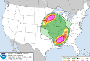
The tornado was part of a historic and deadly tornado outbreak that unfolded across the central United States on March 3–4, 2030. The Storm Prediction Center (SPC) issued a rare double High Risk outlook for tornadoes—one centered over central Mississippi and another over southern Minnesota and northern Iowa. This marked the first time since 2023 that two separate High Risk zones were issued simultaneously, both driven by tornadic potential rather than hail or wind.
The southern High Risk zone targeted Mississippi, where an EF5 tornado devastated Starkville earlier in the day. Meanwhile, the northern High Risk zone encompassed southern Minnesota, where conditions rapidly deteriorated after sunset. A Marginal Risk area extended across parts of the Great Plains, primarily for damaging winds associated with a fast-moving squall line.
Storm initiation began in Iowa between 9:00 and 10:00 p.m. CST as a potent upper-level trough overspread a highly unstable and sheared environment. Surface dewpoints surged into the upper 60s°F, with temperatures in the low 70s°F across southern Minnesota—exceptionally rare for early March. A strong low-level jet intensified to 70–80 knots, enhancing helicity values to over 600 m²/s² in the warm sector. Mixed-layer CAPE values ranged from 3,500 to 4,200 J/kg, supporting robust updrafts capable of sustaining long-lived supercells.
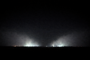
At 12:27 a.m. CST on March 4, the Dodge Center tornado touched down in Freeborn County. It quickly intensified, aided by a deeply curved hodograph and strong directional shear in the lowest 3 km. The tornado remained on the ground for 1 hour and 14 minutes, tracking nearly 74 miles through southeastern Minnesota. Radar imagery showed a persistent and intense debris ball, with dual-polarization signatures indicating lofted debris exceeding 80,000 feet.
The synoptic setup featured:
• 500 mb jet streak: 110–120 knots
• Surface low pressure: ~987 mb centered over eastern Nebraska
• Effective SRH: 550–650 m²/s²
• 0–1 km shear: 40–50 knots
• EHI values: 6.5–8.0 across the High Risk corridor
• STP (Significant Tornado Parameter): locally exceeding 10 in southern Minnesota
These values, combined with nocturnal instability and minimal CINH, created an environment highly conducive to violent, long-track tornadoes. The Dodge Center tornado became the most intense of the outbreak, and the first tornado ever rated EF6 following the Enhanced Fujita scale update in late 2029.
Development and track

The tornado developed from a rapidly intensifying supercell that emerged over northern Iowa late on March 3, 2030. Between 9:00 and 10:00 p.m. CST, storms initiated along a sharpening dryline and warm front intersection, supported by a powerful 987 mb surface low over eastern Nebraska and a 120-knot mid-level jet streak. As the supercell moved northeast into southern Minnesota, it encountered an environment characterized by extreme low-level shear, surface dewpoints in the upper 60s°F, and effective SRH values exceeding 600 m²/s².
At 12:27 a.m. CST on March 4, the tornado touched down in rural Freeborn County, Minnesota, just southwest of Bath. Within seconds, it intensified to EF4 strength, causing deep ground scouring and damaging vehicles along Interstate 35. The tornado continued northeast, maintaining EF4–EF5 intensity as it passed near Geneva and directly impacted Ellendale, where homes and farmsteads were severely damaged.
The tornado then tracked through Summit, Union, and Bixby, reaching EF5 strength near Highway 218. It sustained this intensity as it approached Dodge Center, where it reached peak strength. At approximately 12:52 a.m. CST, the tornado cored U.S. Highway 14 and entered Dodge Center at EF6 intensity, obliterating neighborhoods, dislodging foundations, and granulating underground infrastructure. Sirens failed to activate due to a system outage, leaving residents with little to no warning. Mobile Doppler radar would scan the tornado as it impacted the city of Dodge Center, and they would find a reading of 344 mph (554 km/h). This would break the record of the 1999 Bridge Creek–Moore tornado for the strongest tornado in history worldwide. They overlooked the data over time and still received the same result.
After devastating Dodge Center, the tornado continued northeast, directly impacting Mantorville at EF5 strength. Sirens again failed to activate, contributing to high casualties. The tornado then crossed rural areas before striking the city of Oronoco, initially at EF5 strength before weakening to EF4. Sirens failed in Oronoco as well. Beyond Oronoco, the tornado maintained EF4 strength as it impacted South Troy and homes west of Hammond, where sirens were operational and likely prevented further loss of life.
The tornado began to occlude near Hammond and lifted at 1:41 a.m. CST, after remaining on the ground for 1 hour and 14 minutes and traveling 73.7 miles across southeastern Minnesota. Its path width peaked at 1.5 miles, and damage indicators reached 270 mph, marking it as the first tornado ever rated EF6 following the Enhanced Fujita scale update in late 2029.
Impact

The tornado left a trail of devastation across southeastern Minnesota, becoming the deadliest and most destructive tornado in the state’s history. Over the course of its 73.7-mile path, the tornado directly impacted multiple communities, including Freeborn, Ellendale, Bixby, Dodge Center, Mantorville, Genoa, Oronoco, and South Troy. It resulted in 253 fatalities and 1,525 injuries, with the majority concentrated in Dodge Center, where the tornado reached EF6 intensity.
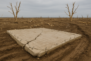
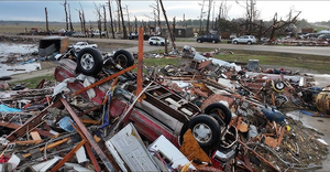
In Dodge Center, the tornado cored U.S. Highway 14 and obliterated entire neighborhoods. Sirens failed to activate due to a system outage, leaving residents with no warning. Structures were swept from their foundations, some of which were cracked and dislodged. Underground plumbing was ripped out and granulated. Vehicles were thrown hundreds of yards, and debris was windrowed miles downwind. Surveyors documented damage indicators of up to 270 mph, the highest ever recorded, along with getting the fastest sustained windspeed ever recorded at 344 mph.
Mantorville and Oronoco also suffered severe losses, both experiencing direct hits from the tornado’s EF5 core. Sirens failed in both towns, contributing to elevated casualty counts. South Troy and the homes west of Hammond were impacted by the tornado’s final EF4 surge before occlusion, with sirens functioning in that area and likely preventing further fatalities.
The tornado also crossed Interstate 35 near Bath at EF5 strength, catching vehicles and RVs in the dark. Additional fatalities occurred along Highway 218 near Bixby and U.S. Highway 14 in Dodge Center, where nighttime conditions and lack of warning led to catastrophic outcomes for motorists.
Emergency services were overwhelmed. In Dodge Center, storm spotters were the first to arrive and described the city as “completely unrecognizable.” One survivor said, “It was like a nuclear bomb went off and erased everything.” The final death toll took nearly two weeks to confirm due to the extent of destruction and difficulty in locating victims.
The tornado’s impact extended beyond physical damage. Hospitals across southern Minnesota were inundated with patients, and mutual aid was required from neighboring states. The event prompted a reevaluation of siren infrastructure and emergency alert protocols statewide.
Aftermath

In the wake of the tornado, southeastern Minnesota faced a humanitarian and logistical crisis. The sheer scale of destruction—especially in Dodge Center, Mantorville, and Oronoco—overwhelmed local emergency services. Search and rescue operations were hampered by debris fields, impassable roads, and widespread infrastructure collapse. In Dodge Center alone, it took nearly two weeks to finalize the death toll due to the extent of structural obliteration and difficulty locating victims.
Hospitals across the region were inundated with trauma cases, prompting mutual aid from neighboring states. Rochester’s Mayo Clinic activated its mass casualty protocols, receiving hundreds of patients from the tornado zone. Temporary triage centers were established in school gyms and community centers, some of which had narrowly escaped damage themselves.
The failure of tornado sirens in Dodge Center, Mantorville, and Oronoco became a focal point of public outrage and investigation. State officials launched a full audit of emergency alert systems, and legislation was proposed to mandate redundant siren networks and real-time diagnostic monitoring. The National Weather Service also revised its emergency communication protocols to better account for infrastructure vulnerabilities during high-risk events.
In the weeks following the tornado, thousands of volunteers, including storm spotters, first responders, and National Guard units, assisted with recovery efforts. Entire neighborhoods were cleared of debris, and temporary housing was provided for displaced residents. Federal disaster declarations unlocked emergency funding, but rebuilding was expected to take years.
The tornado’s EF6 rating—assigned under the updated Enhanced Fujita scale—sparked national debate about the limits of tornado intensity and the adequacy of current building codes. Meteorologists and engineers cited the Dodge Center event as a case study in extreme wind engineering, with damage indicators exceeding anything previously documented.
Memorials were held across affected towns, and March 4 was declared a statewide day of remembrance. Survivors described the event as “apocalyptic,” and many communities began investing in underground shelters and advanced warning systems. The Dodge Center tornado became a defining moment in Minnesota’s weather history, reshaping both policy and public consciousness around severe weather preparedness.
Quote
Quote from a NWS Surveyor with NWS La Crosse:
“It was unlike anything I have ever seen. I’ve had my fair share of rating tornadoes, along with researching the strongest tornadoes to ever exist. This is certainly close, if not overtaking the damage done in Smithville, Mississippi, in 2011, and Jarrell, Texas, in 1997. This damage was, by far, some of the worst I’ve ever seen in my entire life… Either on the screen, or in person.”
Part of
The tornado was part of the tornado outbreak of March 3–4, 2030, a widespread and deadly severe weather event that affected multiple states across the central and southern United States. The outbreak featured a rare double High Risk issued by the Storm Prediction Center—one over central Mississippi and another over southern Minnesota and northern Iowa—both driven by tornadic potential. The outbreak produced numerous violent tornadoes, including an EF5 that struck Starkville, Mississippi, and the EF6 Dodge Center tornado, which became the deadliest in Minnesota history.
See also
- 2030 Ackerman–Starkville tornado–an EF5 tornado that occurred earlier in the outbreak which became the costliest on record
- Tornadoes of 2030
- Tornado outbreak of March 3–4, 2030
- List of tornado records


