
2025 Alisea Hurricane Season (Hurr.Alex): Difference between revisions
| (46 intermediate revisions by 2 users not shown) | |||
| Line 1: | Line 1: | ||
{{Infobox Hurricane Season|lowest pressure= | {{Infobox Hurricane Season|name=2025 Alisea Hurricane Season|lowest pressure=931 mbar (hPa; 27.49 inHg)|maximum winds={{convert|150|mph|km/h|abbr=on}}<br />''(1 minute sustained)''|image caption=2025 Alisea Season summary map|first system formed=Jan 25, 2025|total dp=10|total storms=10|total hurricanes=5 |total fatalities=Unknown |total damage=Unknown| image location=2025 Alisea Season Summery.jpg|five seasons=2023, 2024, '''2025''', 2026, 2027|total mhurricanes sshws=1|last system dissipated=Season ongoing|articles=None|strongest-storm=Jordan}} | ||
The '''2025 Alisea hurricane season''' is a current event in the annual tropical cyclone season in the northern hemisphere. The season officially begins on May 14, 2025, and will end on November 30, 2025. These dates historically describe the period each year when most tropical cyclones form in the Alisea basin and are adopted by convention. However, as illustrated by Tropical Storm Abigail, the formation of tropical cyclones is possible at any time of the year. This season started exceptionally early, nearly five months before the official start, with Tropical Storm Abigail forming Near die Berge des Landes (Country) in mid-January. With Beth forming on May 13th it would mark the First Time where two pre-seasons happened in the Basin since 2020. | The '''2025 Alisea hurricane season''' is a current event in the annual tropical cyclone season in the northern hemisphere. The season officially begins on May 14, 2025, and will end on November 30, 2025. These dates historically describe the period each year when most tropical cyclones form in the Alisea basin and are adopted by convention. However, as illustrated by Tropical Storm Abigail, the formation of tropical cyclones is possible at any time of the year. This season started exceptionally early, nearly five months before the official start, with Tropical Storm Abigail forming Near die Berge des Landes (Country) in mid-January. With Beth forming on May 13th it would mark the First Time where two pre-seasons happened in the Basin since 2020. | ||
{{Clear}} | {{Clear}} | ||
| Line 72: | Line 72: | ||
| '''Actual activity'''<br /> | | '''Actual activity'''<br /> | ||
| | | | ||
| | |5 | ||
| | |1 | ||
|0 | |0 | ||
|- | |- | ||
| Line 84: | Line 84: | ||
Additional forecasts were issued by the NAC (National Arrocane Center), MV, and the LL. On May 9, NAC forecasted 17 named storms, 9 hurricanes, and 4 major hurricanes. MV, on May 10, predicted 16 named storms, 10 hurricanes, and 4 major hurricanes. LL also released its outlook on May 10, forecasting 14 to 17 named storms, 5 to 7 hurricanes, and 2 to 4 major hurricanes,A later forecast from the NAC (National Arrocane Center) was released on May 25, raising expectations for the season to 16 to 20 named storms, 8 to 11 hurricanes, and 3 to 5 major hurricanes. | Additional forecasts were issued by the NAC (National Arrocane Center), MV, and the LL. On May 9, NAC forecasted 17 named storms, 9 hurricanes, and 4 major hurricanes. MV, on May 10, predicted 16 named storms, 10 hurricanes, and 4 major hurricanes. LL also released its outlook on May 10, forecasting 14 to 17 named storms, 5 to 7 hurricanes, and 2 to 4 major hurricanes,A later forecast from the NAC (National Arrocane Center) was released on May 25, raising expectations for the season to 16 to 20 named storms, 8 to 11 hurricanes, and 3 to 5 major hurricanes. | ||
{{Clear}} | {{Clear}} | ||
==Seasonal timeline== | ==Seasonal timeline== | ||
| Line 135: | Line 118: | ||
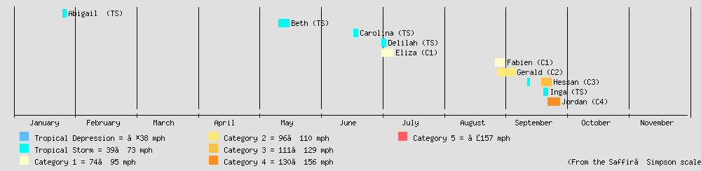
from:25/01/2025 till:27/01/2025 color:TS text:"Abigail (TS)" | from:25/01/2025 till:27/01/2025 color:TS text:"Abigail (TS)" | ||
from:12/05/2025 till:17/05/2025 color:TS text:"Beth (TS)" | from:12/05/2025 till:17/05/2025 color:TS text:"Beth (TS)" | ||
from: | from:18/06/2025 till:20/06/2025 color:TS text:"Carolina (TS)" | ||
from:02/07/2025 till:04/07/2025 color:TS text:"Delilah (TS)" | |||
from:02/07/2025 till:08/07/2025 color:C1 text:"Eliza (C1)" | |||
from:27/08/2025 till:01/09/2025 color:C1 text:"Fabien (C1)" | |||
from:28/08/2025 till:06/09/2025 color:C2 text:"Gerald (C2)" | |||
from:12/09/2025 till:13/09/2025 color:TS | |||
barset:break | |||
barset:skip | |||
barset:skip | |||
barset:skip | |||
barset:skip | |||
barset:skip | |||
barset:skip | |||
barset:skip | |||
from:19/09/2025 till:24/09/2025 color:C3 text:"Hessan (C3)" | |||
from:20/09/2025 till:22/09/2025 color:TS text:"Inga (TS)" | |||
from:22/09/2025 till:28/09/2025 color:C4 text:"Jordan (C4)" | |||
bar:Month width:5 align:center fontsize:S shift:(0,-20) anchor:middle color:canvas | bar:Month width:5 align:center fontsize:S shift:(0,-20) anchor:middle color:canvas | ||
from:01/01/2025 till:31/01/2025 text:January | from:01/01/2025 till:31/01/2025 text:January | ||
| Line 160: | Line 159: | ||
== Systems == | == Systems == | ||
=== Tropical Storm Abigail === | === Tropical Storm Abigail === | ||
{{Infobox Hurricane System|1-min winds=45|basin=atl|duration=January 25-January 27, 2025|pressure=1002|track=Abigail 2025 | {{Infobox Hurricane System|1-min winds=45|basin=atl|duration=January 25-January 27, 2025|pressure=1002|track=Abigail 2025 Track.jpg|image=Abigail 2025-01-26-0600Z.png|scale-type=SSHWS}} | ||
A tropical wave Forms South of die Berge des Landes on January 24, 2025, and moved Northwest across the Alisea Ocean. By 18:00 UTC on January 25, the system organized sufficiently to be classified as a subtropical storm South of die Berge des Landes and the National Alerian Hurricane Center (NAHC), receiving the name Abigail. Initially exhibiting subtropical characteristics, the storm transitioned into a fully tropical system by 12:00 UTC on January 26 as it moved closer to the Western coast of die Berge des Landes. | A tropical wave Forms South of die Berge des Landes on January 24, 2025, and moved Northwest across the Alisea Ocean. By 18:00 UTC on January 25, the system organized sufficiently to be classified as a subtropical storm South of die Berge des Landes and the National Alerian Hurricane Center (NAHC), receiving the name Abigail. Initially exhibiting subtropical characteristics, the storm transitioned into a fully tropical system by 12:00 UTC on January 26 as it moved closer to the Western coast of die Berge des Landes. | ||
| Line 170: | Line 169: | ||
=== Tropical Storm Beth=== | === Tropical Storm Beth=== | ||
{{Infobox Hurricane System|1-min winds=65|basin=atl|duration=May 13, 2025 - May 16, 2025|pressure=993|track=Beth 2025 | {{Infobox Hurricane System|1-min winds=65|basin=atl|duration=May 13, 2025 - May 16, 2025|pressure=993|track=Beth 2025 Track.jpg|image=Beth 2025-05-15-1200Z.png|scale-type=SSHWS|}} | ||
A tropical wave formed southeast of Saint Luis Island on May 12, 2025, and tracked generally northwestward. By 12:00 UTC on May 13, the system had gained sufficient organization to be classified as a tropical depression. Continued intensification prompted NAHC to upgrade the system to Tropical Storm Beth at 06:00 UTC on May 14. | A tropical wave formed southeast of Saint Luis Island on May 12, 2025, and tracked generally northwestward. By 12:00 UTC on May 13, the system had gained sufficient organization to be classified as a tropical depression. Continued intensification prompted NAHC to upgrade the system to Tropical Storm Beth at 06:00 UTC on May 14. | ||
| Line 180: | Line 179: | ||
=== Tropical Storm Carolina=== | === Tropical Storm Carolina=== | ||
{{Infobox Hurricane System | {{Infobox Hurricane System | ||
| basin = atl | |||
| 1-min winds = 45 | | 1-min winds = 45 | ||
| scale-type = SSHWS | |||
| pressure = 998 | |||
| duration = June 18 – 20, 2025 | |||
| image = Carolina 06-19-2025 1800Z.png | |||
| track = Carolina 2025 Track.jpg | |||
}} | |||
Carolina originated from a tropical wave that Formed off the east coast of New London on 16 June, as it moved closer to land the Wave reached Tropical Depression Status on 18 June 06Z, as the Depression continued to move closer to land it would reach Tropical Storm on 19 June at 00Z before making landfall 12 Hours later just to the South of the City of New London, as Carolina moved inland it weaken down to a Tropical Depression, weakening down to a Remanet low Later dissipate over southern New London. | |||
{{Clear}} | |||
=== Tropical Storm Dalilah=== | |||
{{Infobox Hurricane System | |||
| basin = atl | |||
| 1-min winds = 40 | |||
| scale-type = SSHWS | | scale-type = SSHWS | ||
| pressure = 997 | | pressure = 997 | ||
| duration = | | duration = Jul 2-Jul 4, 2025 | ||
| image = | | image = Dalilah Jul 3 2025 1800Z.png | ||
| track = | | track = Dalila 2025 Track.jpg | ||
}} | |||
{{Clear}} | |||
=== Hurricane Eliza=== | |||
{{Infobox Hurricane System | |||
| basin = atl | |||
| 1-min winds = 80 | |||
| scale-type = SSHWS | |||
| pressure = 989 | |||
| duration = Jul 2-Jul 8, 2025 | |||
| image = Eliza Jul 5 2025 1200Z.png | |||
| track = Eliza 2025 Track.jpg | |||
|basin=atl}} | |||
{{Clear}} | |||
=== Hurricane Fabian=== | |||
{{Infobox Hurricane System | |||
| basin = atl | |||
| 1-min winds = 85 | |||
| scale-type = SSHWS | |||
| pressure = 982 | |||
| duration = Aug 27-Sep 1, 2025 | |||
| image = Fabian Aug 29 2025 1800Z.png | |||
| track = Fabian 2025 Track.jpg | |||
|basin=atl}} | |||
{{Clear}} | |||
=== Hurricane Gerald=== | |||
{{Infobox Hurricane System | |||
| basin = atl | |||
| 1-min winds = 100 | |||
| scale-type = SSHWS | |||
| pressure = 976 | |||
| duration = Aug 28-Sep 6, 2025 | |||
| image = Gerald Sep 6 2025 0600Z.png | |||
| track = Gerald 2025 Track.jpg | |||
}} | |||
{{Clear}} | |||
=== Hurricane Hessan=== | |||
{{Infobox Hurricane System | |||
| basin = atl | |||
| 1-min winds = 120 | |||
| scale-type = SSHWS | |||
| pressure = 960 | |||
| duration = Sep 12-Sep 24, 2025 | |||
| image = Hessan Sep 22 2025 0600Z.png | |||
| track = Hessan 2025 Track.jpg | |||
}} | |||
{{Clear}} | |||
=== Tropical Storm Inga=== | |||
{{Infobox Hurricane System | |||
| basin = atl | |||
| 1-min winds = 50 | |||
| scale-type = SSHWS | |||
| pressure = 997 | |||
| duration = Sep 20-Sep 22, 2025 | |||
| image = Inga Sep 21 2025 1200Z.png | |||
| track = Inga 2025 Track.jpg | |||
}} | |||
{{Clear}} | |||
=== Hurricane Jordan=== | |||
{{Infobox Hurricane System | |||
| basin = atl | |||
| 1-min winds = 150 | |||
| scale-type = SSHWS | |||
| pressure = 931 | |||
| duration = Sep 22-Sep 28, 2025 | |||
| image = Jordan Sep 25 2025 2300Z.png | |||
| track = Jordan 2025 Track.jpg | |||
}} | }} | ||
{{Clear}} | {{Clear}} | ||
| Line 196: | Line 281: | ||
* Abigail | * Abigail | ||
* Beth | * Beth | ||
* | * Carolina | ||
* | * Delilah | ||
* | * Eliza | ||
* | * Fabien | ||
* | * Gerald | ||
| | | | ||
* | * Hessan | ||
* | * Inga | ||
* | * Jordan | ||
* {{tcname unused|Kevin}} | * {{tcname unused|Kevin}} | ||
* {{tcname unused|Louise}} | * {{tcname unused|Louise}} | ||
Latest revision as of 18:51, 6 September 2025
| 2025 Alisea Hurricane Season | |
 2025 Alisea Season summary map | |
| Seasonal boundaries | |
|---|---|
| First system formed | Jan 25, 2025 |
| Last system dissipated | Season ongoing |
| Strongest storm | |
| Name | Jordan |
| • Maximum winds | 150 mph (240 km/h) (1 minute sustained) |
| • Lowest pressure | 931 mbar (hPa; 27.49 inHg) |
| Seasonal statistics | |
| Total depressions | 10 |
| Total storms | 10 |
| Total hurricanes | 5 |
| Major hurricanes (Cat. 3+) |
1 |
| Total fatalities | Unknown |
| Total damage | Unknown |
| Related articles | |
None
| |
|
| |
| Atlantic hurricane seasons 2023, 2024, 2025, 2026, 2027 | |
The 2025 Alisea hurricane season is a current event in the annual tropical cyclone season in the northern hemisphere. The season officially begins on May 14, 2025, and will end on November 30, 2025. These dates historically describe the period each year when most tropical cyclones form in the Alisea basin and are adopted by convention. However, as illustrated by Tropical Storm Abigail, the formation of tropical cyclones is possible at any time of the year. This season started exceptionally early, nearly five months before the official start, with Tropical Storm Abigail forming Near die Berge des Landes (Country) in mid-January. With Beth forming on May 13th it would mark the First Time where two pre-seasons happened in the Basin since 2020.
Seasonal forecasts
| Source | Date | Named storm |
Hurricanes | Major hurricanes | |||
| Average (1991–2020) | 14.4 | 7.2 | 3.2 | ||||
| Record high activity | 30 | 14 | 7 | ||||
| Record low activity | 2 | 1† | 0† | ||||
| NAHC | Apr 5, 2025 | 13-16 | 4-6 | 2-3 | |||
| NAHC | Apr 28, 2025 | 14-19 | 4-6 | 1-3 | |||
| NAHC | May 9, 2025 | 14-19 | 7-8 | 1-2 | |||
| NAC | May 9, 2025 | 17 | 9 | 4 | |||
| MV | May 10, 2025 | 16 | 10 | 4 | |||
| LL | May 10, 2025 | 14-17 | 5-7 | 2-4 | |||
| NAC | May 25, 2025 | 16-20 | 8-11 | 3-5 | |||
| Actual activity |
5 | 1 | 0 | ||||
Prior to the start of the 2025 Alisea hurricane season, several forecasting agencies issued predictions for tropical cyclone activity in the region. These forecasts projected the number of named storms, hurricanes, and major hurricanes (Category 3 or higher on the Saffir–Simpson scale). The 30-year average from 1991 to 2020 for the basin is 14.4 named storms, 7.2 hurricanes, and 3.2 major hurricanes.
The North Alisean Hurricane Center (NAHC) released three forecasts. The initial outlook on April 5 projected a slightly below-average season, with 13 to 16 named storms, 4 to 6 hurricanes, and 2 to 3 major hurricanes. This was followed by updates on April 28 and May 9, both maintaining the named storm range at 14 to 19. The May 9 forecast adjusted the expected hurricanes to 7 to 8 and major hurricanes to 1 to 2.
Additional forecasts were issued by the NAC (National Arrocane Center), MV, and the LL. On May 9, NAC forecasted 17 named storms, 9 hurricanes, and 4 major hurricanes. MV, on May 10, predicted 16 named storms, 10 hurricanes, and 4 major hurricanes. LL also released its outlook on May 10, forecasting 14 to 17 named storms, 5 to 7 hurricanes, and 2 to 4 major hurricanes,A later forecast from the NAC (National Arrocane Center) was released on May 25, raising expectations for the season to 16 to 20 named storms, 8 to 11 hurricanes, and 3 to 5 major hurricanes.
Seasonal timeline
Systems
Tropical Storm Abigail
| Tropical storm (SSHWS) | |
|---|---|
  | |
| Duration | January 25-January 27, 2025 |
| Peak intensity | 45 mph (72 km/h) (1-min); 1002 mbar (hPa) |
A tropical wave Forms South of die Berge des Landes on January 24, 2025, and moved Northwest across the Alisea Ocean. By 18:00 UTC on January 25, the system organized sufficiently to be classified as a subtropical storm South of die Berge des Landes and the National Alerian Hurricane Center (NAHC), receiving the name Abigail. Initially exhibiting subtropical characteristics, the storm transitioned into a fully tropical system by 12:00 UTC on January 26 as it moved closer to the Western coast of die Berge des Landes.
At its peak, Tropical Storm Abigail reached maximum sustained winds of 45 mph (72 km/h) and a minimum central pressure of 1002 mbar (hPa). The system maintained tropical storm strength for a relatively short period before undergoing extratropical transition by 12:00 UTC on January 27. The resulting extratropical cyclone persisted over the Gulf of New Britian and dissipated by 18:00 UTC on January 30.
Despite its brief lifespan and moderate intensity, Abigail Caused Little to No Damage and 1 Death.
Tropical Storm Beth
| Tropical storm (SSHWS) | |
|---|---|
  | |
| Duration | May 13, 2025 - May 16, 2025 |
| Peak intensity | 65 mph (105 km/h) (1-min); 993 mbar (hPa) |
A tropical wave formed southeast of Saint Luis Island on May 12, 2025, and tracked generally northwestward. By 12:00 UTC on May 13, the system had gained sufficient organization to be classified as a tropical depression. Continued intensification prompted NAHC to upgrade the system to Tropical Storm Beth at 06:00 UTC on May 14.
Beth gradually strengthened as it curved toward the northeast, reaching its peak intensity at 00:00 UTC on May 15 with maximum sustained winds of 65 mph (105 km/h) and a minimum central pressure of 993 mbar (hPa). Later that same day, by 18:00 UTC, Beth transitioned into an extratropical cyclone as it passed north of Mažosios Anglijos. The extratropical remnant of Beth persisted for another day before fully dissipating by 18:00 UTC on May 16.
Beth did not make landfall, but its outer bands brought gusty winds and increased surf to the nearby coasts.
Tropical Storm Carolina
| Tropical storm (SSHWS) | |
|---|---|
  | |
| Duration | June 18 – 20, 2025 |
| Peak intensity | 45 mph (72 km/h) (1-min); 998 mbar (hPa) |
Carolina originated from a tropical wave that Formed off the east coast of New London on 16 June, as it moved closer to land the Wave reached Tropical Depression Status on 18 June 06Z, as the Depression continued to move closer to land it would reach Tropical Storm on 19 June at 00Z before making landfall 12 Hours later just to the South of the City of New London, as Carolina moved inland it weaken down to a Tropical Depression, weakening down to a Remanet low Later dissipate over southern New London.
Tropical Storm Dalilah
| Tropical storm (SSHWS) | |
|---|---|
  | |
| Duration | Jul 2-Jul 4, 2025 |
| Peak intensity | 40 mph (64 km/h) (1-min); 997 mbar (hPa) |
Hurricane Eliza
| Category 1 hurricane (SSHWS) | |
|---|---|
  | |
| Duration | Jul 2-Jul 8, 2025 |
| Peak intensity | 80 mph (130 km/h) (1-min); 989 mbar (hPa) |
Hurricane Fabian
| Category 1 hurricane (SSHWS) | |
|---|---|
  | |
| Duration | Aug 27-Sep 1, 2025 |
| Peak intensity | 85 mph (137 km/h) (1-min); 982 mbar (hPa) |
Hurricane Gerald
| Category 2 hurricane (SSHWS) | |
|---|---|
  | |
| Duration | Aug 28-Sep 6, 2025 |
| Peak intensity | 100 mph (160 km/h) (1-min); 976 mbar (hPa) |
Hurricane Hessan
| Category 3 hurricane (SSHWS) | |
|---|---|
  | |
| Duration | Sep 12-Sep 24, 2025 |
| Peak intensity | 120 mph (190 km/h) (1-min); 960 mbar (hPa) |
Tropical Storm Inga
| Tropical storm (SSHWS) | |
|---|---|
  | |
| Duration | Sep 20-Sep 22, 2025 |
| Peak intensity | 50 mph (80 km/h) (1-min); 997 mbar (hPa) |
Hurricane Jordan
| Category 4 hurricane (SSHWS) | |
|---|---|
  | |
| Duration | Sep 22-Sep 28, 2025 |
| Peak intensity | 150 mph (240 km/h) (1-min); 931 mbar (hPa) |
Storm names
The following list of names will be used for named storms that form in the Alisea in 2025. This is the same list used in the 2019 season, with the exception of Inga, which replaced Irma .
|
|
|