
1979 Reimagined Atlantic Hurricane Season; HELL Edition (HA Animations): Difference between revisions
No edit summary |
|||
| (22 intermediate revisions by 2 users not shown) | |||
| Line 1: | Line 1: | ||
{{Infobox Hurricane Season|lowest pressure=876|maximum winds=195|stormname=|last system dissipated=November | {{Infobox Hurricane Season|lowest pressure=876|maximum winds=195|stormname=|last system dissipated=November 15, 1979|image caption=Season summary map|first system formed=June 12, 1979|total dp=29 (Record High)|total storms=27 (Record High)|total hurricanes=13 (Record High)|total fatalities=23,944|total damage=$29.8 Billion (1979 USD)|articles=|image location=1979NATLReimaginedHELL.png|five seasons=1979|strongest-storm=Kate|total mhurricanes sshws=7 (Record High)|ace=261.4075 (Record High)|record-damage=Costliest Atlantic Hurricane season on record}} | ||
== Seasonal Summary == | |||
The '''1979 Atlantic Hurricane Season''' was a record-breaking and extremely devastating series. This season is the first of an ongoing series of HA Animations' HELL Series, in which tropical cyclone seasons are reimagined to be far more devastating while also being loosely based on the real-world counterpart of the season. This series begins in 1979, the beginning of the usage of male-female alternating lists, which is considered the beginning of the "modern" Atlantic Naming Lists. | |||
The 1979 Atlantic Hurricane Season would begin on June 12, with Hurricane Ana, which made several landfalls in the Caribbean and the Southeastern United States. Ana would make an exceptionally rare Georgia landfall, making landfall in Savannah, Georgia at peak intensity. Shortly after, Bob would form in the far western Tropical Atlantic. Bob would become a category two hurricane in the Eastern Caribbean, and would make landfall in Hispaniola as a category one storm before going out to sea for the remainder of its life. In early July, Tropical Storm Claudette, Hurricane David, and Tropical Storm Elena would form, with Claudette remaining mainly out to sea, with the exception of a tropical storm landfall in Bermuda. David and Elena would experience a Fujiwara Interaction, in which David absorbed Elena shortly after Elena made landfall in Extreme Southern South Carolina. Hurricane David would peak as a category two hurricane in the Gulf of Mexico, before making landfall near Pensacola, Florida on July 13th. | |||
==Seasonal timeline== | ==Seasonal timeline== | ||
| Line 11: | Line 17: | ||
AlignBars = early | AlignBars = early | ||
DateFormat = dd/mm/yyyy | DateFormat = dd/mm/yyyy | ||
Period = from:01/06/ | Period = from:01/06/1979 till:30/11/1979 | ||
TimeAxis = orientation:horizontal | TimeAxis = orientation:horizontal | ||
ScaleMinor = grid:black unit:month increment:1 start:01/06/ | ScaleMinor = grid:black unit:month increment:1 start:01/06/1979 | ||
Colors = | Colors = | ||
| Line 25: | Line 31: | ||
id:C4 value:rgb(1,0.45,0.54) legend:Category_4_=_130-159_mph_(209-256_km/h) | id:C4 value:rgb(1,0.45,0.54) legend:Category_4_=_130-159_mph_(209-256_km/h) | ||
id:C5 value:rgb(0.55,0.46,0.90) legend:Category_5_=_160-224_mph_(257-360_km/h) | id:C5 value:rgb(0.55,0.46,0.90) legend:Category_5_=_160-224_mph_(257-360_km/h) | ||
Backgroundcolors = canvas:canvas | Backgroundcolors = canvas:canvas | ||
| Line 36: | Line 40: | ||
PlotData= | PlotData= | ||
barset:Hurricane width:11 align:left fontsize:S shift:(4,-4) anchor:till | barset:Hurricane width:11 align:left fontsize:S shift:(4,-4) anchor:till | ||
from: | from:12/06/1979 till:16/06/1979 color:C1 text:"Ana (C1)" | ||
from:23/06/1979 till:28/06/1979 color:C2 text:"Bob (C2)" | |||
from:10/07/1979 till:12/07/1979 color:TS text:"Claudette (TS)" | |||
from:11/07/1979 till:13/07/1979 color:C2 text:"David (C2)" | |||
from:13/07/1979 till:13/07/1979 color:TS text:"Elena (TS)" | |||
from: | |||
from: | |||
from: | |||
from: | |||
bar:Month width:5 align:center fontsize:S shift:(0,-20) anchor:middle color:canvas | bar:Month width:5 align:center fontsize:S shift:(0,-20) anchor:middle color:canvas | ||
from:01/06/ | from:01/06/1979 till:30/06/1979 text:June | ||
from:01/07/ | from:01/07/1979 till:31/07/1979 text:July | ||
from:01/08/ | from:01/08/1979 till:31/08/1979 text:August | ||
from:01/09/ | from:01/09/1979 till:30/09/1979 text:September | ||
from:01/10/ | from:01/10/1979 till:31/10/1979 text:October | ||
from:01/11/ | from:01/11/1979 till:30/11/1979 text:November | ||
TextData = | TextData = | ||
pos:( | pos:(800,23) | ||
text:"(From the" | text:"(From the" | ||
pos:( | pos:(860,23) | ||
text:"[[ | text:"[[Saffir–Simpson scale]])" | ||
</timeline>}} | </timeline>}} | ||
==Systems== | ==Systems== | ||
=== Hurricane | ===Hurricane Kate=== | ||
{{Infobox Hurricane System|1-min winds= | {{Infobox Hurricane System | ||
{{main|Hurricane | | 1-min winds = 195 | ||
| scale-type = sshws | |||
| basin = atl | |||
| pressure = 876 | |||
| duration = August 25 – September 7 | |||
| image = Temporary_cyclone_north.svg | |||
| track = | |||
}} | |||
<!--{{main|Hurricane Kate (HA Animations)}}--> | |||
{{Clear}} | |||
==Storm names== | ==Storm names== | ||
The following names have been designated for the ''' | The following names have been designated for the '''1979 Atlantic hurricane season''': | ||
{| style="width:100%;" | {| style="width:100%;" | ||
| Line 115: | Line 108: | ||
==Season effects== | ==Season effects== | ||
{{ | {{Saffir-Simpson scale small}} | ||
<center>{{TC stats table start3|year= | <center>{{TC stats table start3|year=1979|basin=Atlantic hurricane}} | ||
{{TC stats | {{TC stats cyclone SSHWS | ||
| cat=sshwscat1 | |||
| max-winds=90 | |||
| name=Ana | |||
| dates=June 12–16 | |||
| min-press=983 | |||
| areas=Jamaica, Cuba, Bahamas, Southeast United States | |||
{{TC stats table end3|num-cyclones= | | damage=$276 Million | ||
| deaths=94 | |||
| refs= | |||
}} | |||
{{TC stats table end3|num-cyclones= 0|dates=N/A|max-winds= 0| min-press=0|tot-areas= |tot-damage= $0|tot-deaths= 0}} | |||
</center> | </center> | ||
Latest revision as of 18:31, 5 October 2025
| 1979 Reimagined Atlantic Hurricane Season; HELL Edition (HA Animations) | |
 Season summary map | |
| Seasonal boundaries | |
|---|---|
| First system formed | June 12, 1979 |
| Last system dissipated | November 15, 1979 |
| Strongest storm | |
| Name | Kate |
| • Maximum winds | 195 mph (314 km/h) (1-minute sustained) |
| • Lowest pressure | 876 mbar (hPa; 25.87 inHg) |
| Seasonal statistics | |
| Total depressions | 29 (Record High) |
| Total storms | 27 (Record High) |
| Total hurricanes | 13 (Record High) |
| Major hurricanes (Cat. 3+) |
7 (Record High) |
| ACE | 261.4075 (Record High) |
| Total fatalities | 23,944 |
| Total damage | $29.8 Billion (1979 USD) (Costliest Atlantic Hurricane season on record) |
| Related articles | |
|
| |
| Atlantic hurricane seasons 1979 | |
Seasonal Summary
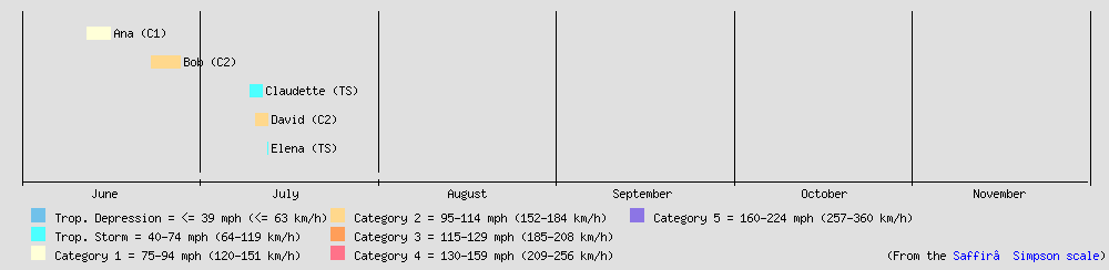
The 1979 Atlantic Hurricane Season was a record-breaking and extremely devastating series. This season is the first of an ongoing series of HA Animations' HELL Series, in which tropical cyclone seasons are reimagined to be far more devastating while also being loosely based on the real-world counterpart of the season. This series begins in 1979, the beginning of the usage of male-female alternating lists, which is considered the beginning of the "modern" Atlantic Naming Lists.
The 1979 Atlantic Hurricane Season would begin on June 12, with Hurricane Ana, which made several landfalls in the Caribbean and the Southeastern United States. Ana would make an exceptionally rare Georgia landfall, making landfall in Savannah, Georgia at peak intensity. Shortly after, Bob would form in the far western Tropical Atlantic. Bob would become a category two hurricane in the Eastern Caribbean, and would make landfall in Hispaniola as a category one storm before going out to sea for the remainder of its life. In early July, Tropical Storm Claudette, Hurricane David, and Tropical Storm Elena would form, with Claudette remaining mainly out to sea, with the exception of a tropical storm landfall in Bermuda. David and Elena would experience a Fujiwara Interaction, in which David absorbed Elena shortly after Elena made landfall in Extreme Southern South Carolina. Hurricane David would peak as a category two hurricane in the Gulf of Mexico, before making landfall near Pensacola, Florida on July 13th.
Seasonal timeline
Systems
Hurricane Kate
| Category 5 hurricane (SSHWS) | |
|---|---|
 | |
| Duration | August 25 – September 7 |
| Peak intensity | 195 mph (314 km/h) (1-min); 876 mbar (hPa) |
Storm names
The following names have been designated for the 1979 Atlantic hurricane season:
Season effects
| Saffir-Simpson scale | ||||||||||||||||
| TD | TS | C1 | C2 | C3 | C4 | C5 | ||||||||||
| Storm name |
Dates active | Storm category at peak intensity |
Max 1-min wind mph (km/h) |
Min. press. (mbar) |
Areas affected | Damage (USD) |
Deaths | Ref(s). | ||
|---|---|---|---|---|---|---|---|---|---|---|
| Ana | June 12–16 | Category 1 hurricane | 90 (145) | 983 | Jamaica, Cuba, Bahamas, Southeast United States | $276 Million | 94 | |||
| Season aggregates | ||||||||||
| 0 systems | N/A | 0 | 0 | $0 | 0 | |||||