
2019 Ardonia arrocane season: Difference between revisions
No edit summary |
No edit summary |
||
| Line 185: | Line 185: | ||
{{main|Arrocane Arlene}} | {{main|Arrocane Arlene}} | ||
{{Infobox Hurricane System|1-min winds=180|scale-type=aaws|pressure=899|duration=May 17 – May 30|image=Arlene_2300_AT_5212019.png|track=Arlene_Full_Track.png}} | {{Infobox Hurricane System|1-min winds=180|scale-type=aaws|pressure=899|duration=May 17 – May 30|image=Arlene_2300_AT_5212019.png|track=Arlene_Full_Track.png}} | ||
Arrocane '''Arlene''' was the first named storm of the season and the most powerful arrocane ever recorded in the Ardonia basin. Forming on May 17 over the central Gulf of Ardonia, Arlene underwent explosive intensification, reaching Category 5 strength just four days later with peak sustained winds of '''180 mph (290 km/h)''' and a minimum central pressure of '''899 mbar''', both new basin records. | |||
Arlene became the **earliest Category 5 arrocane on record**, and the first to make landfall at that intensity. On May 22, it slammed into southern '''Cydonia''' with sustained winds of '''175 mph (282 km/h)''' and a pressure of '''908 mbar''', making it the **most intense landfalling storm** in Ardonian history. After crossing the region, it curved northeastward, delivering destructive conditions to parts of '''K’arthen''' and eastern '''Crown Peak''' before becoming extratropical on May 27 and dissipating three days later. | |||
The storm broke a total of **15 records**, including highest storm surge ('''50.75 ft'''), highest confirmed wave height ('''99.3 ft'''), most rainfall from an arrocane ('''250.59 in'''), and smallest observed eye ('''4.4 mi'''). Arlene maintained Category 5 strength for '''30 hours''', the longest in basin history, and underwent the fastest intensification ever observed, with a 24-hour increase of '''70 mph''' in wind speed and a pressure drop of '''69 mbar'''. | |||
Arlene caused catastrophic damage across southern Ardonia, particularly in '''Meridian''', '''Po’Hatu''', '''Phaethon''', and '''Blade Island''', resulting in '''113 confirmed deaths''', over '''2,500 injuries''', and at least '''$24.9 billion AC''' in damage. Preliminary assessments from '''NAC/NWS Port Kazu''' suggest Arlene may ultimately be the **costliest and deadliest arrocane** in modern records. | |||
{{Clear}} | {{Clear}} | ||
Revision as of 19:55, 29 ⧼may_long⧽ 2025
| 2019 Ardonia arrocane season | |
| No image provided | |
| Seasonal boundaries | |
|---|---|
| First system formed | May 17, 2019 |
| Last system dissipated | Season ongoing |
| Strongest storm | |
| Name | Arlene (Strongest and most intense storm ever recorded) |
| • Maximum winds | [convert: invalid number] (1-minute sustained) |
| • Lowest pressure | Error: Invalid or missing pressure value. |
| Seasonal statistics | |
| Total depressions | 2 |
| Total storms | 2 |
| Arrocanes | 1 |
| Major arrocanes (Cat. 3+) |
1 |
| Total fatalities | 113 total |
| Total damage | ≥$24.9 billion (2019 AC) |
| Related articles | |
|
| |
| Ardonia arrocane seasons 2019, 2020 | |
The 2019 Ardonia arrocane season is the ongoing annual period in which tropical cyclones—known regionally as arrocanes—form in the Ardonian Ocean and adjacent waters. The season officially began on May 15 and will end on October 31, dates which conventionally delimit the period each year when arrocanes are most likely to develop across the region. The season is monitored by the National Arrocane Center (NAC) in Ataraxia, with local coordination provided by regional National Weather Service (NWS) offices across the continent.
So far, the season has featured the formation of two named storms: Arrocane Arlene, which reached Category 5 intensity and became the strongest storm ever recorded in the basin, and Tropical Storm Beryl, a short-lived but record-breaking system over the southeastern Ardonian Ocean. Arlene caused significant impacts to multiple regions of Ardonia and is still ongoing, while Beryl remained entirely at sea and caused no reported damage or fatalities.
The 2019 season follows the 1865 season which was historic and has already produced multiple record-setting events, with additional activity possible in the coming months.
Seasonal forecasts
| Source | Date | Named storm |
Arrocanes | Major arrocanes | |||
| Average (1865) | 13 | 5 | 3 | ||||
| Record high activity | 13 | 5 | 3 | ||||
| Record low activity | 13 | 5 | 3 | ||||
| NAC | March 31, 2019 | 16-20 | 8-11 | 3-6 | |||
| VW | May 16, 2019 | 17 | 10 | 5 | |||
| T1X | May 16, 2019 | 18 | 12 | 6 | |||
| NAHC | May 16, 2019 | 18-22 | 9-12 | 1-4 | |||
| EX | May 16, 2019 | 24 | 9 | 4 | |||
| NF | May 17, 2019 | 17-21 | 6-11 | 2-4 | |||
| ECT | May 17, 2019 | 20 | 10 | 4 | |||
| HDC | May 17, 2019 | 17 | 9 | 4 | |||
| HA | May 17, 2019 | 18 | 9 | 4 | |||
| NAC | May 19, 2019 | 21-24 | 13-17 | 5-8 | |||
| VOLT | May 20, 2019 | 18 | 9 | 3 | |||
| LA | May 21, 2019 | 14 | 7 | 3 | |||
| Actual activity |
2 | 1 | 1 | ||||
Prior to the official start of the 2019 Arrocane season, multiple meteorological agencies across Ardonia issued forecasts anticipating an active year. The National Arrocane Center (NAC) released its early outlook on March 31, calling for 16 to 20 named storms, 8 to 11 arrocanes, and 3 to 6 major arrocanes. A revised outlook published on May 19 increased those ranges to 21 to 24 named storms, 13 to 17 arrocanes, and 5 to 8 major systems.
Forecasts from other agencies varied in intensity, but a majority anticipated an above-average or near-record season. Voltage/Jordinium (VOLT) and Viewer (VW) predicted 18 and 17 named storms respectively, while T1xfed (T1X) projected as many as 12 full arrocanes and 6 majors. The North Alisean Hurricane Center (NAHC) issued one of the highest forecasts, predicting 18 to 22 named storms and 9 to 12 arrocanes.
Several other regional centers released forecasts in mid-May. Exile (EX) forecast 24 named storms and 9 arrocanes, while Nevaeh (NF) predicted 17 to 21 storms and 6 to 11 arrocanes, including up to four major systems. ECThunderstorms (ECT) called for 20 named storms and 10 arrocanes, and Hurricane Dave (HDC) projected a similar outlook with 17 storms and 9 arrocanes. Lastly, HA Animations (HA) predicted 19 named storms and 10 arrocanes, with the potential for 4 major events.
The surge in predictions was attributed to anticipated above-normal sea surface temperatures across the Gulf of Ardonia and an ongoing phase of the Southern Trade Oscillation (STO), which historically correlates with heightened cyclonic activity in the region. Several agencies, including the NAC and HA, noted the potential for multiple Category 4 and 5 arrocanes.
As of now, the season has seen the development of only two named storms—Arrocane Arlene, a Category 5 system still active, and Tropical Storm Beryl, a minimal storm that remained at sea. Though early activity has not matched forecasted expectations, experts caution that the peak of the season typically occurs between July and September.
LIVE outlook

Seasonal timeline
Systems
Arrocane Arlene
| Category 5 arrocane (AAWS) | |
|---|---|
 | |
| Duration | May 17 – May 30 |
| Peak intensity | 180 mph (290 km/h) (1-min); 899 mbar (hPa) |
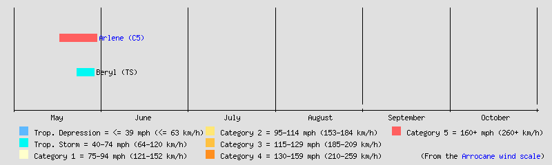
Arrocane Arlene was the first named storm of the season and the most powerful arrocane ever recorded in the Ardonia basin. Forming on May 17 over the central Gulf of Ardonia, Arlene underwent explosive intensification, reaching Category 5 strength just four days later with peak sustained winds of 180 mph (290 km/h) and a minimum central pressure of 899 mbar, both new basin records.
Arlene became the **earliest Category 5 arrocane on record**, and the first to make landfall at that intensity. On May 22, it slammed into southern Cydonia with sustained winds of 175 mph (282 km/h) and a pressure of 908 mbar, making it the **most intense landfalling storm** in Ardonian history. After crossing the region, it curved northeastward, delivering destructive conditions to parts of K’arthen and eastern Crown Peak before becoming extratropical on May 27 and dissipating three days later.
The storm broke a total of **15 records**, including highest storm surge (50.75 ft), highest confirmed wave height (99.3 ft), most rainfall from an arrocane (250.59 in), and smallest observed eye (4.4 mi). Arlene maintained Category 5 strength for 30 hours, the longest in basin history, and underwent the fastest intensification ever observed, with a 24-hour increase of 70 mph in wind speed and a pressure drop of 69 mbar.
Arlene caused catastrophic damage across southern Ardonia, particularly in Meridian, Po’Hatu, Phaethon, and Blade Island, resulting in 113 confirmed deaths, over 2,500 injuries, and at least $24.9 billion AC in damage. Preliminary assessments from NAC/NWS Port Kazu suggest Arlene may ultimately be the **costliest and deadliest arrocane** in modern records.
Tropical Storm Beryl
| Tropical storm (AAWS) | |
|---|---|
  | |
| Duration | May 23 – May 29 |
| Peak intensity | 65 mph (105 km/h) (1-min); 989 mbar (hPa) |
Tropical Storm Beryl was the second named storm of the season, forming from a low-pressure system over the southeastern Ardonian Ocean on early on May 23. The system gradually organized and reached tropical storm strength by May 25, remaining entirely over open waters throughout its lifespan. Beryl peaked with sustained winds of 65 mph (105 km/h) and a minimum central pressure of 989 mbar on the early morning of May 26 before transitioning into an extratropical cyclone on May 27. It dissipated completely by May 28 at 2300 Ardonian time and by 0000 on May 29 in terms of Zulu time.
Although Beryl caused no damage or fatalities, it broke multiple historical records dating back to the Great Arrocane Year of 1865. It became the strongest tropical storm on record for the basin by windspeed, surpassing all previous non-hurricane systems. Beryl also entered the top 10 most intense arrocanes by pressure, ranking just behind Tropical Storm Eleven of 1865 (988 mbar), according to the NAC/NWS. Despite its limited impact, Beryl’s meteorological significance earned it a place in the basin’s historical records.
Storm names
The following names have been designated for the 2019 Ardonia arrocane season:
|
|
|
|
Season effects
| Ardonia arrocane wind scale | ||||||||||||||||
| TD | TS | C1 | C2 | C3 | C4 | C5 | ||||||||||
| Storm name |
Dates active | Storm category at peak intensity |
Max 1-min wind mph (km/h) |
Min. press. (mbar) |
Areas affected | Damage (USD) |
Deaths | Ref(s). | ||
|---|---|---|---|---|---|---|---|---|---|---|
| Season aggregates | ||||||||||
| 0 systems | Season not started | Season not started | Season not started | Season not started | Season not started | |||||