2030 Moore tornado
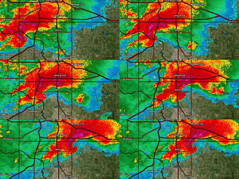
Bottom: Radar loop of the tornado as it went through Moore. | |
| Meteorological history | |
|---|---|
| Formed | May 11, 2030, 1:21 p.m. CDT (UTC-5:00) |
| Dissipated | May 11, 2030, 2:07 p.m. CDT (UTC-5:00) |
| Duration | 46 minutes |
| EF5 tornado | |
| on the Enhanced Fujita scale | |
| Path length | 15.1 miles (24.3 km) |
| Highest winds | 205 mph (330 km/h) |
| Overall effects | |
| Fatalities | 35+ |
| Injuries | 315+ |
| Damage | ~$2.1 billion (2030 USD) |
| Areas affected | Cleveland and Oklahoma Counties in Oklahoma, mainly the city of Moore |
|
| |
| Part of the Tornado outbreak of May 11-12, 2030 and Tornadoes of 2030 | |
The 2030 Moore tornado was a catastrophic and violent EF5 tornado that struck the city of Moore, Oklahoma on May 11, 2030. As part of a larger tornado outbreak affecting the Southern Plains, this tornado caused widespread devastation across Cleveland and Oklahoma counties, leaving a trail of destruction reminiscent of the deadly tornadoes that struck the region in 1999 and 2013. The tornado reached a peak intensity of EF5 on the Enhanced Fujita scale, with estimated winds of 205 mph (330 km/h), and carved a destructive path through densely populated areas, making it one of the most intense tornadoes to impact the United States in recent history.
This was the third EF5 tornado to strike the city of Moore, following the devastating events of May 3, 1999, and May 20, 2013. It also marked the third EF5 tornado to occur in the United States since 2013, breaking a nearly two-decade lull in top-rated tornadoes. Despite the widespread damage throughout the city, the National Weather Service assigned the EF5 rating based on a single damage indicator: the complete destruction of a well-constructed restaurant in southern Moore. The rest of the tornado’s damage, while extreme and consistent with EF4 intensity, did not meet the required damage indicators for an EF5 rating. However, the destruction of the restaurant, which had been bolted to its foundation and engineered to high standards, supported winds well over 200 mph.
Meteorological synopsis

On May 11, 2030, an intense mid- to upper-level trough emerged into the Southern Plains from the Desert Southwest, providing deep-layer ascent across Oklahoma and northern Texas. A strong 500 mb jet max of 90–100 knots overspread the region, resulting in significant upper-level divergence. At the surface, a rapidly deepening low-pressure system centered near the eastern Texas Panhandle helped draw a warm front northward across central Oklahoma. This frontal boundary intersected a sharpening dryline stretching from southwestern Oklahoma into western Kansas, forming a textbook triple point scenario.
The environment featured extreme instability, with surface temperatures reaching 86 °F and dewpoints around 73 °F. Surface-based CAPE exceeded 4450 J/kg, while 0–3 km lapse rates reached 8.7 C/km and 3–6 km lapse rates neared 7.4 C/km, indicating a deep, unstable profile conducive to strong updraft acceleration. Storm-relative helicity values were measured at 457 m²/s², supportive of intense low-level rotation. Although PWAT values were modest at 0.4 inches, the environment remained primed for tornadic supercells due to dry air aloft and strong vertical wind shear. A robust low-level jet also contributed to strong moisture transport and storm-relative inflow.
Surface analysis and mesoscale observations confirmed strong moisture convergence near the triple point, where initial supercells rapidly formed. Additional support from a diffluent upper flow pattern and deep-layer shear of 50+ knots allowed for rapid supercell organization. Hodographs taken from Norman and other central Oklahoma soundings displayed large, clockwise-curved profiles in the lowest 3 km, indicative of enhanced tornado potential.
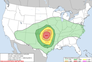
The Storm Prediction Center issued a Moderate Risk for severe weather with a focused threat for strong to violent tornadoes. A Particularly Dangerous Situation (PDS) tornado watch was issued by early afternoon. Environmental soundings taken from central Oklahoma showed a large, curved hodograph, indicating strong directional shear and long hodograph loops ideal for cyclic tornadogenesis. By early afternoon, discrete supercells began forming in the triple point region, with one storm rapidly intensifying southwest of Moore and producing the tornado that would become the day's most destructive.
Development and track
Formation and initial intensification
The tornado first touched down at 1:21 p.m. CDT near Newcastle, Oklahoma, in a rural field. It began as a weak circulation producing EF0 to EF1 damage, but rapidly intensified as it moved northeast. The first area of significant damage occurred just west of Moore in an agricultural field, where EF4-level ground scouring was observed. Topsoil was completely removed, and a small metal structure was obliterated.
South Oklahoma City
As the tornado crossed into the southern portions of Oklahoma City and Moore city limits, it entered a phase of rapid intensification and widening. Radar indicated a developing debris ball, and wind velocity readings increased sharply. Trees were shredded, power poles snapped, and homes on the edge of Moore suffered increasingly severe damage. This area experienced high-end EF3 to low-end EF4 damage, serving as a precursor to the catastrophic devastation that would follow.
Moore
Upon reaching south-central Moore, the tornado expanded to nearly 1 mile in width. The storm produced widespread EF4 damage to entire neighborhoods, with homes swept from foundations and vehicles thrown several hundred yards. It passed over Plaza Towers Elementary School, which was destroyed for the second time in just over 15 years. However, due to the storm striking on a Saturday, the school was unoccupied and no fatalities occurred there. The tornado's peak damage occurred in this region, with the destruction of a well-built and bolted-down restaurant, justifying the EF5 rating.
Weakening and dissipation
After passing through central and eastern Moore, the tornado began to weaken as it moved toward Lake Stanley Draper. Damage transitioned from EF4 to EF2 intensity, with trees uprooted and the destruction of outbuildings and barns. The tornado finally dissipated at 2:07 p.m., leaving a path of destruction 15.1 miles long and nearly a mile wide at its peak.
Impact
Damages
Over 2,000 structures were damaged or destroyed, including homes, schools, farms, and commercial businesses. Entire blocks of neighborhoods were reduced to rubble. The hardest hit areas included neighborhoods along 4th Street and Santa Fe Avenue, where nearly every structure was flattened. Critical infrastructure including water treatment facilities and cell towers were impacted, hampering response and communication in the hours following the storm.
Briarwood Elementary School
Briarwood Elementary sustained roof and wall damage, with several classrooms severely impacted. Fortunately, like Plaza Towers, it was closed for the weekend. The structure was found to have partially failed due to uplift, despite code improvements made after the 2013 tornado.
Plaza Towers Elementary School
Plaza Towers, having been rebuilt after the 2013 EF5, was again directly hit. Its new reinforced concrete construction held up better than the original facility, though the outer walls, windows, and roof were heavily damaged. Debris was scattered across its grounds. Officials later stated that the upgrades likely prevented a repeat of the 2013 tragedy.
Other regions
Beyond Moore, parts of South Oklahoma City and unincorporated Cleveland County sustained EF2 to EF3 damage. Scattered power outages extended into Norman and Midwest City. Rural homes along the western edge of the tornado’s path experienced EF3 damage to barns, vehicles, and tree lines.
Casualties
The death toll rose to at least 35, with more than 315 injuries reported. Several people were killed in vehicles, others in mobile homes or poorly anchored shelters. Recovery of victims was hampered by debris, flooding from burst pipes, and blocked roads. Identification and confirmation of casualties took nearly three weeks due to the scale of destruction.
Aftermath
Initial aid
Within hours, search-and-rescue teams were deployed from across Oklahoma and neighboring states. The Oklahoma National Guard and FEMA led recovery and coordination efforts. Over 30 temporary shelters were activated, and over 3,000 individuals were displaced. Food banks, mobile kitchens, and Red Cross units provided essential services. Emergency crews cleared key corridors first to allow for medical transport and power restoration.
Television changes and documentary specials
Several local stations suspended normal programming to provide wall-to-wall coverage for days. A series of memorial specials and survivor interviews aired nationally in the following weeks. Documentary crews from PBS and The Weather Channel embedded with Moore responders to produce retrospective specials highlighting resilience, engineering, and recovery.
See also
Tornado outbreak of May 11-12, 2030
1999 Bridge Creek–Moore tornado
Part of
The 2030 Moore tornado was the most destructive tornado in a two-day outbreak that produced 19 confirmed tornadoes across Oklahoma, Kansas, and Missouri. Alongside the Moore tornado, the outbreak included the 2030 El Reno EF4 tornado and several EF2–EF3 events. The moderate-risk forecast verified with multiple cyclic supercells and high-end thermodynamic profiles contributing to violent tornado development across the Southern Plains. The outbreak reaffirmed central Oklahoma’s unfortunate status as one of the most tornado-prone regions in the world.

