Arrocane Camille
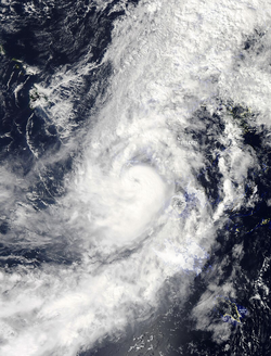
 Camille near peak intensity over the western Ardonian Ocean on June 4 | |
| Meteorological history | |
|---|---|
| Formed | June 1, 2019 |
| Remnant Low | June 5, 2019 |
| Dissipated | June 7, 2019 |
| Category 2 arrocane | |
| 1-minute sustained (AAWS/NWS) | |
| Highest winds | 100 mph (160 km/h) |
| Lowest pressure | 973 mbar (hPa); 28.73 inHg |
| Overall effects | |
| Fatalities | 6 total |
| Injuries | 20+ |
| Missing | 1 |
| Damage | ≥$2.8 billion (2019 AC) (Preliminary results via the NAC and NWS Ferndale) |
| Areas affected |
|
|
| |
| Part of the 2019 Ardonia arrocane season | |
Arrocane Camille was a high-end Category 2 tropical cyclone that caused significant damage across western Felden and surrounding regions during early June 2019. As the third named storm and second arrocane of the 2019 Ardonia arrocane season, Camille became the **most intense Category 2 arrocane ever recorded** in the Ardonia basin and ranked among the **top ten strongest** overall by both windspeed and pressure. The storm reached peak intensity with **sustained winds of 100 mph (161 km/h)** and a **minimum pressure of 973 mbar**, surpassing the intensity of Category 2 Arrocane Eight (1865) by one millibar.
Camille caused **six confirmed deaths**, injured more than **20 people**, and left one person missing. Total damages were estimated at **≥2.8 billion AC**, placing it as the **fourth costliest arrocane** in recorded basin history, behind Arlene (2019), Nine (1865), and Seven (1865). The storm struck multiple cities and settlements across Felden and eventually weakened inland by June 7.
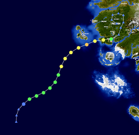
Meteorological history

Tropical storm (40–74 mph, 64–120 km/h)
Category 1 (75–94 mph, 121–152 km/h)
Category 2 (95–114 mph, 153–184 km/h)
Category 3 (115–129 mph, 185–209 km/h)
Category 4 (130–159 mph, 210–259 km/h)
Category 5 (≥ 160 mph, ≥ 260 km/h)
Unknown
Arrocane Camille originated from a tropical disturbance in the northeastern Ardonian Ocean on June 1. Under favorable conditions—warm sea surface temperatures and minimal vertical wind shear—the system gradually consolidated and was classified as a tropical storm within 18 hours. Camille steadily intensified as it tracked west-northwestward, entering a zone of enhanced outflow and developing a well-defined core.
By June 3, Camille had reached Category 1 strength, and on June 4 it peaked as a **high-end Category 2 arrocane**, with **1-minute sustained winds of 100 mph** and a **central pressure of 973 mbar**. The system's compact structure and symmetrical core allowed it to maintain intensity while approaching the Felden coastline. On June 6, Camille made landfall in western Felden at Category 1 intensity, with winds near 85 mph.
After landfall, Camille weakened quickly while moving inland across elevated terrain. It was downgraded to a remnant low on June 5 but continued producing heavy rainfall before dissipating entirely on June 7 over the far northeastern Ardonian interior.
| Rank | Arrocane | Season | Pressure | |
|---|---|---|---|---|
| hPa | inHg | |||
| 1 | Milton | 2019 | 865 | 25.54 |
| 2 | Arlene | 2019 | 899 | 26.55 |
| 3 | Katrina | 2019 | 901 | 26.61 |
| 4 | Nine | 1865 | 911 | 26.90 |
| 5 | Florence | 2019 | 925 | 27.32 |
| 6 | Wilma | 2019 | 931 | 27.49 |
| 7 | Seven | 1865 | 929 | 27.43 |
| 8 | Rita | 2019 | 937 | 27.67 |
| 9 | Xander | 2019 | 949 | 28.02 |
| 10 | Six | 1865 | 951 | 28.08 |
| Source: NAC/NWS | ||||
Preparations
The NAC issued arrocane watches and warnings for portions of western Felden, including coastal zones along the Basalt Coast and the Kawaiin Islands, as Camille approached the continent. Local NWS offices in Ferndale and Looma activated emergency protocols and distributed warnings through local radio networks and bulletin systems. Schools and government offices in Riverstead, Fort Zuka, and Ferndale were closed ahead of landfall, and low-lying neighborhoods near the Mahoa Docks and Felora were placed under voluntary evacuation orders.
Impact
| Rank | Arrocane | Season | Damage |
|---|---|---|---|
| 1 | 5 Arlene | 2019 | $158 billion |
| 2 | 5 Milton | 2019 | $75 billion |
| 3 | 4 Katrina | 2019 | $59 billion |
| 4 | 3 Florence | 2019 | $45 billion |
| 5 | 4 Rita | 2019 | $37.6 billion |
| 6 | 4 Wilma | 2019 | $29.5 billion |
| 7 | 3 Victor | 2019 | $19.9 billion |
| 8 | 1 Camille | 2019 | $16 billion |
| 9 | 4 Nine | 1865 | $10.2 billion |
| 10 | 4 Seven | 1865 | $5.87 billion |
Camille brought damaging winds, flash flooding, and coastal erosion to a broad region of western Felden. Wind gusts near landfall exceeded 95 mph, toppling trees and damaging poorly constructed buildings. Rainfall totals ranged from 8 to 14 inches across the impact zone, causing localized flash floods in mountainous areas such as Mount Tempus and Riverstead.
The hardest-hit areas included the **Basalt Coast**, **Kawaiin Islands**, and **Ferndale**, where significant power outages and transportation disruptions were reported. Additional damage occurred in **Niika’s Treefort**, **Hamburville**, and **Thralkeld**, where mudslides and blocked roads isolated some communities for over 24 hours. Agricultural losses in the Basalt Mines and surrounding valley zones were also reported.
In total, the NAC confirmed **six fatalities**, more than **20 injuries**, and **one person missing**. Preliminary economic losses were estimated at **2.8 billion AC**, with infrastructure damage concentrated along the coast and in river-adjacent settlements.
Aftermath
Cleanup and recovery operations were launched by the Felden provincial government, with support from the NAC and national response agencies. Debris removal and restoration of power lines were prioritized in Ferndale and Looma, while inland rescue efforts focused on clearing flooded roadways and reconnecting isolated mountain towns.
Emergency relief centers were established in Mahoa Docks and Fort Zuka to shelter displaced residents. The AMO noted that Camille's intensity, while below major status, demonstrated that mid-strength systems could still produce high-impact disasters, especially in densely populated or mountainous regions.
