Arrocane Milton: Difference between revisions
No edit summary |
No edit summary |
||
| Line 27: | Line 27: | ||
'''Arrocane Milton''' was an extremely powerful and devastating tropical cyclone which in 2019, became the strongest, and most intense ever recorded in the basin. Milton made 2 devastating Category 5 landfalls in Meridian, Cydonia, 2 months after the devastating [[Arrocane Arlene]] tore through the city 2 months prior. The thirteenth named storm, eighth arrocane, fifth major arrocane, and the third and final [[List of Category 5 arrocanes|Category 5 arrocane]] of the [[2019 Ardonia arrocane season]]. | '''Arrocane Milton''' was an extremely powerful and devastating tropical cyclone which in 2019, became the strongest, and most intense ever recorded in the basin. Milton made 2 devastating Category 5 landfalls in Meridian, Cydonia, 2 months after the devastating [[Arrocane Arlene]] tore through the city 2 months prior. The thirteenth named storm, eighth arrocane, fifth major arrocane, and the third and final [[List of Category 5 arrocanes|Category 5 arrocane]] of the [[2019 Ardonia arrocane season]]. | ||
Milton originated from a long-lived tropical wave that originated over the Gulf of Ardonia on July 10, and would consolidate on July 11. Intensification occurred shortly after it's formation as it moved over very warm waters within the Gulf of Ardonia. Milton would intensify into a Category 1 arrocane by July 14, and underwent explosive intensification soon after, and would become a Category 5 arrocane with 1-minute sustained winds of {{convert|175|mph|km/h|abbr=on}} just 18 hours later. At peak intensity, Milton had a central pressure of {{convert|877|mb|inHg|sigfig=4}} and 1-minute sustained windspeeds of {{convert|195|mph|km/h|abbr=on}}, making it the strongest (windspeed), and most intense (pressure) arrocane on record in the entire world. Milton would weaken for a short period of time due to an eyewall replacement cycle which lasted 12 hours. After the cycle, Milton would again strengthen to Category 5 status and reach 1-minute sustained windspeeds of {{convert| | Milton originated from a long-lived tropical wave that originated over the Gulf of Ardonia on July 10, and would consolidate on July 11. Intensification occurred shortly after it's formation as it moved over very warm waters within the Gulf of Ardonia. Milton would intensify into a Category 1 arrocane by July 14, and underwent explosive intensification soon after, and would become a Category 5 arrocane with 1-minute sustained winds of {{convert|175|mph|km/h|abbr=on}} just 18 hours later. At peak intensity, Milton had a central pressure of {{convert|877|mb|inHg|sigfig=4}} and 1-minute sustained windspeeds of {{convert|195|mph|km/h|abbr=on}}, making it the strongest (windspeed), and most intense (pressure) arrocane on record in the entire world. Milton would weaken for a short period of time due to an eyewall replacement cycle which lasted 12 hours. After the cycle, Milton would again strengthen to Category 5 status and reach 1-minute sustained windspeeds of {{convert|185|mph|km/h|abbr=on}} which would pass [[Arrocane Arlene]] for a second time. After it's second peak, Milton would speed up as it approached Meridian and weaken due to increased wind shear. Milton would make 2 seperate landfalls in Meridian at Category 5 intensity with 1-minute sustained windspeeds of {{convert|165|mph|km/h|abbr=on}} each, and minimum central pressures of {{convert|919|mb|inHg|sigfig=4}} and {{convert|920|mb|inHg|sigfig=4}} respectively. | ||
==Meteorological history== | ==Meteorological history== | ||
Revision as of 11:12, 4 ⧼september⧽ 2025
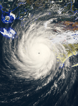
 Milton at it's record peak intensity over the Gulf of Ardonia on July 14 | |
| Meteorological history | |
|---|---|
| Formed | July 11, 2019 |
| Extratropical | July 18, 2019 |
| Dissipated | July 20, 2019 |
| Category 5 major arrocane | |
| 1-minute sustained (AAWS/NWS) | |
| Highest winds | 195 mph (314 km/h) (Fastest 1-minute sustained winds ever recorded) |
| Lowest pressure | 877 mbar (hPa); 25.90 inHg (Worldwide record low) |
| Overall effects | |
| Fatalities | 437 (Second-deadliest tropical cyclone on record) |
| Injuries | 2,953 |
| Missing | 9 |
| Damage | $75 billion (2019 AC) (Second-costliest tropical cyclone on record) |
| Areas affected |
|
|
| |
| Part of the 2019 Ardonia arrocane season | |
Arrocane Milton was an extremely powerful and devastating tropical cyclone which in 2019, became the strongest, and most intense ever recorded in the basin. Milton made 2 devastating Category 5 landfalls in Meridian, Cydonia, 2 months after the devastating Arrocane Arlene tore through the city 2 months prior. The thirteenth named storm, eighth arrocane, fifth major arrocane, and the third and final Category 5 arrocane of the 2019 Ardonia arrocane season.
Milton originated from a long-lived tropical wave that originated over the Gulf of Ardonia on July 10, and would consolidate on July 11. Intensification occurred shortly after it's formation as it moved over very warm waters within the Gulf of Ardonia. Milton would intensify into a Category 1 arrocane by July 14, and underwent explosive intensification soon after, and would become a Category 5 arrocane with 1-minute sustained winds of 175 mph (282 km/h) just 18 hours later. At peak intensity, Milton had a central pressure of 877 millibars (25.90 inHg) and 1-minute sustained windspeeds of 195 mph (314 km/h), making it the strongest (windspeed), and most intense (pressure) arrocane on record in the entire world. Milton would weaken for a short period of time due to an eyewall replacement cycle which lasted 12 hours. After the cycle, Milton would again strengthen to Category 5 status and reach 1-minute sustained windspeeds of 185 mph (298 km/h) which would pass Arrocane Arlene for a second time. After it's second peak, Milton would speed up as it approached Meridian and weaken due to increased wind shear. Milton would make 2 seperate landfalls in Meridian at Category 5 intensity with 1-minute sustained windspeeds of 165 mph (266 km/h) each, and minimum central pressures of 919 millibars (27.14 inHg) and 920 millibars (27.17 inHg) respectively.
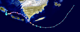
Meteorological history

Tropical storm (40–74 mph, 64–120 km/h)
Category 1 (75–94 mph, 121–152 km/h)
Category 2 (95–114 mph, 153–184 km/h)
Category 3 (115–129 mph, 185–209 km/h)
Category 4 (130–159 mph, 210–259 km/h)
Category 5 (≥ 160 mph, ≥ 260 km/h)
Unknown
Records
| Rank | Arrocane | Season | Windspeed (MPH) |
|---|---|---|---|
| 1 | 5 Milton | 2019 | 200 mph (320 km/h) |
| 2 | 5 Arlene | 2019 | 180 mph (290 km/h) |
| 3 | 5 Katrina | 2019 | 175 mph (282 km/h) |
| 4 | 5 Nine | 1865 | 165 mph (266 km/h) |
| 5 | 4 Florence | 2019 | 150 mph (240 km/h) |
| 6 | 4 Seven | 1865 | 145 mph (233 km/h) |
| 4 Wilma | 2019 | ||
| 8 | 4 Rita | 2019 | 140 mph (230 km/h) |
| 9 | 3 Six | 1865 | 125 mph (201 km/h) |
| 3 Xander | 2019 |
Milton broke a total of 6 records in the Ardonian basin, mainly for strength and intensification. Those that are listed in RED have been broken, or tied with other storms:
- Strongest sustained winds on record (195 mph)
- Lowest pressure on record (877 mbar)
- First M-named storm to reach category 1+ strength
- Longest duration of Category 5 intensity (30 hours) Tied with Arlene
- Smallest observed eye diameter (2.2 mi)
- Fastest intensification: 120 mph increase and 109 mbar drop in 24 hours
