2025 Mankato tornado: Difference between revisions
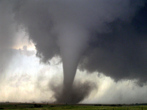
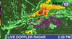
Created page with "{{Infobox weather event/EF | multiple image = {{multiple image | border = infobox | perrow = 1/2 | total_width = 250 | image1 = 2025 Mankato MN EF5.png | image2 = Mankato EF5 KEYC Radar.jpeg}} |image caption= '''Top:''' The tornado as it tracked across Route 21 into North Mankato.<br />'''Bottom:''' Radar imagery of the tornado over Mankato. |formed=March 21, 2025, 1:54 p.m. CDT (UTC-5:00) |dissipated=March 21, 2025, 2:36 p.m. CDT (UTC-5:00) |duration=42 minutes |highest..." |
No edit summary |
||
| Line 41: | Line 41: | ||
==Tornado summary== | ==Tornado summary== | ||
[[File:2025 Mankato tornado forming. | [[File:2025 Mankato tornado forming.png|thumb|The tornado as it begins to form near U.S. Highway 169 at 1:52 PM.]] | ||
The '''2025 Mankato EF5 tornado''' was a violent and devastating tornado that ravaged parts of '''North Mankato''' and '''Mankato''' on the afternoon of '''March 21, 2025'''. It was the first of two [[Enhanced Fujita scale|'''EF5 tornadoes''']] to strike southern Minnesota that day, marking an unprecedented event in the state’s history. The tornado carved a destructive path through densely populated urban areas, leaving behind catastrophic damage and a trail of death and devastation. | The '''2025 Mankato EF5 tornado''' was a violent and devastating tornado that ravaged parts of '''North Mankato''' and '''Mankato''' on the afternoon of '''March 21, 2025'''. It was the first of two [[Enhanced Fujita scale|'''EF5 tornadoes''']] to strike southern Minnesota that day, marking an unprecedented event in the state’s history. The tornado carved a destructive path through densely populated urban areas, leaving behind catastrophic damage and a trail of death and devastation. | ||
| Line 62: | Line 62: | ||
The destruction in this commercial zone was particularly devastating due to the high number of people present during the tornado’s approach. Many businesses had only minutes to react to the tornado warnings, and while some employees and customers were able to take shelter in basements and storm-safe areas, others were caught off-guard by the storm’s rapid intensification. The tornado’s winds hurled vehicles across parking lots, with some found lodged in the sides of buildings or embedded in the ground. | The destruction in this commercial zone was particularly devastating due to the high number of people present during the tornado’s approach. Many businesses had only minutes to react to the tornado warnings, and while some employees and customers were able to take shelter in basements and storm-safe areas, others were caught off-guard by the storm’s rapid intensification. The tornado’s winds hurled vehicles across parking lots, with some found lodged in the sides of buildings or embedded in the ground. | ||
[[File:2025 Mankato tornado After hitting. | [[File:2025 Mankato tornado After hitting.png|thumb|left|The tornado as it begins to occlude at 2:31 PM.]] | ||
As the tornado continued its northeastward path, it began to weaken slightly, dropping to [[Enhanced Fujita scale|'''high-end EF3 to EF4 intensity''']]. Despite the weakening, the storm remained deadly, causing significant damage to residential areas and rural properties as it moved away from the commercial zones of Mankato. Homes in these outer regions were either severely damaged or entirely destroyed. Large trees were uprooted, and power lines were torn down, leaving much of the city in darkness. | As the tornado continued its northeastward path, it began to weaken slightly, dropping to [[Enhanced Fujita scale|'''high-end EF3 to EF4 intensity''']]. Despite the weakening, the storm remained deadly, causing significant damage to residential areas and rural properties as it moved away from the commercial zones of Mankato. Homes in these outer regions were either severely damaged or entirely destroyed. Large trees were uprooted, and power lines were torn down, leaving much of the city in darkness. | ||
Latest revision as of 19:25, 29 April 2025
Bottom: Radar imagery of the tornado over Mankato. | |
| Meteorological history | |
|---|---|
| Formed | March 21, 2025, 1:54 p.m. CDT (UTC-5:00) |
| Dissipated | March 21, 2025, 2:36 p.m. CDT (UTC-5:00) |
| Duration | 42 minutes |
| EF5 tornado | |
| on the Enhanced Fujita scale | |
| Highest winds | 210 mph (340 km/h) |
| Overall effects | |
| Fatalities | 37 |
| Injuries | 398 |
| Damage | $2.6 billion (2025 USD) |
| Areas affected | Blue Earth County, mainly the cities of Mankato and North Mankato in Minnesota |
|
| |
| Part of the Tornado outbreak of March 21-22, 2025 and Tornadoes of 2025 | |
The 2025 Mankato tornado was a devastating and catastrophic EF5 tornado which went through parts of southern Minnesota during the early afternoon hour of March 21, 2025. This tornado was a part of the Tornado outbreak of March 21-22, 2025, the Mankato tornado was the first EF5 in 11 years, becoming the second to most recent since May 20, 2013. The Mankato tornado would carve a path through the downtown area of North Mankato and Mankato, causing its most significant damage near Roe Crest Court and Roe Crest Drive. This tornado would even loop over itself over a few homes, causing significant damage.
The Mankato tornado was produced by a young storm, which produced a tornado around 10-20 minutes after the storm's formation. This tornado became known as the first EF5 tornado since 2013. The 2025 Mankato tornado was a long-lived tornado, which would reach EF4-EF5 strength minutes after it's formation. Minnesota hasn't had an F5/EF5 tornado since the 1992 Chandler-Lake Wilson F5.
Meteorological synopsis

The 2025 Mankato EF5 tornado was a product of the intense atmospheric setup that accompanied the Tornado Outbreak of March 21-22, 2025, which swept across the Upper Midwest. This outbreak was particularly significant due to the combination of meteorological factors that created the perfect environment for violent, long-track tornadoes, including the Mankato tornado.
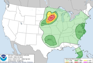
On the morning of March 21, 2025, the Storm Prediction Center (SPC) issued a Moderate Risk for severe weather across much of Minnesota and Iowa, indicating the high likelihood of supercell thunderstorms capable of producing strong, violent tornadoes. While not the highest level of alert, the Moderate Risk reflected a volatile atmosphere primed for explosive storm development later in the day.
A powerful trough was moving eastward across the central Plains, interacting with a surface low-pressure system centered over South Dakota. This low-pressure system created a warm sector across southern Minnesota, where temperatures soared into the upper 70s and low 80s°F—unseasonably warm for March. This warm, moist air was streaming in from the Gulf of Mexico, raising dew points into the upper 60s°F, a critical factor in providing moisture for intense thunderstorm development.
By mid-morning, forecasters noted that the combination of ingredients present over the region would make it highly conducive for supercell development. CAPE (Convective Available Potential Energy) values surged to between 4,000 and 7,000 J/kg—unusually high for this time of year in Minnesota. CAPE levels of this magnitude provided the necessary energy for explosive updrafts within storms. When combined with steep mid-level lapse rates, which created an unstable vertical temperature profile, the environment became increasingly favorable for severe weather.
The real driver of the day's tornadic activity, however, was the extreme wind shear. A 100-120 knot mid-level jet streak was moving over the region, providing strong upper-level divergence that helped to ventilate the storms and keep them sustained. Meanwhile, in the lower levels, a low-level jet was roaring at speeds of 40 to 60 knots, creating significant directional shear. Winds veered from the surface southerly flow to westerly winds aloft, creating a high degree of helicity, with values exceeding 700 to 800 m²/s². This wind profile set the stage for the development of rotating supercells, capable of producing long-track, violent tornadoes like the Mankato EF5.
A critical factor in the development of the Mankato tornado was the presence of a dryline, which extended from central Iowa into southern Minnesota. As the dryline moved eastward throughout the afternoon, it interacted with the warm, moist air mass in place over Minnesota, triggering the development of supercell thunderstorms. The first storms began firing shortly after midday, and by 1:30 PM CDT, the supercell that would spawn the Mankato tornado was already showing signs of intense rotation on radar.
By 1:42 PM, a Tornado Warning was issued for Mankato and the surrounding areas. The supercell exhibited a pronounced hook echo, a signature commonly associated with tornadic activity. As the storm continued to mature, it developed a strong mesocyclone—an area of rotating updrafts within the storm that is crucial for tornado formation. The presence of low-level convergence along the dryline further enhanced the storm’s rotation, and by 1:54 PM, the tornado touched down southwest of North Mankato.
The Mankato tornado rapidly intensified after formation. The supercell moved into an environment with extreme instability and strong wind shear, which allowed the tornado to maintain its EF5 strength for an extended period. The low-level jet continued to supply the storm with warm, moist air, while the upper-level jet provided the necessary divergence to sustain the supercell’s structure. The result was a long-lived, violent tornado that would remain on the ground for 42 minutes, wreaking havoc across a densely populated urban area.
Another crucial factor was the nocturnal cooling that didn’t occur in the late afternoon hours. Despite the typical evening drop in temperatures, the storm’s environment remained warm and humid well into the day. This sustained instability, combined with the ongoing upper-level support, allowed the tornado to maintain its strength longer than typical springtime tornadoes in the Upper Midwest.
The tornado’s path through North Mankato and Mankato is a testament to the raw power of nature, as it intensified due to the combined effects of extreme instability, wind shear, and moisture convergence. In the hours following the tornado, the same atmospheric conditions would continue to produce more violent tornadoes across southern Minnesota, making March 21, 2025, one of the most active and destructive tornado days in the region’s history.
Tornado summary

The 2025 Mankato EF5 tornado was a violent and devastating tornado that ravaged parts of North Mankato and Mankato on the afternoon of March 21, 2025. It was the first of two EF5 tornadoes to strike southern Minnesota that day, marking an unprecedented event in the state’s history. The tornado carved a destructive path through densely populated urban areas, leaving behind catastrophic damage and a trail of death and devastation.
At 1:54 PM CDT, the tornado touched down in a rural area near the junction of U.S. Highway 169 and State Highway 60, just southwest of North Mankato. Initially a smaller storm, it quickly intensified as it moved toward more populated regions. Within minutes of touching down, the storm had grown in size and strength, reaching EF4 intensity. The first signs of catastrophic damage occurred as the tornado tore through the outskirts of North Mankato, obliterating farmhouses and uprooting trees in its path. Survivors in this area reported that the tornado’s roar sounded like a freight train bearing down on them, with debris hurled across fields like missiles.
The tornado's trajectory took it toward the heavily populated Lookout Drive area, where it reached EF5 strength for the first time. The storm swept entire homes off their foundations, leaving behind only slabs of concrete. The tornado’s winds, estimated at 210 mph (340 km/h), stripped trees of their bark and hurled vehicles into the air like toys. Aerial imagery of the area later revealed a half-mile-wide swath of total destruction, where nothing but debris remained. The force of the tornado was so powerful that even underground storm shelters in this area were damaged, with several survivors reporting pressure so intense that it left their ears ringing for days.
As the tornado advanced into North Mankato, its intensity only grew. The storm crossed Belgrade Avenue, where it tore through a commercial district, reducing entire businesses to rubble. Office buildings, restaurants, and shops were flattened. Steel-framed structures were twisted beyond recognition, and debris was scattered for miles. The area around Belgrade Avenue sustained some of the heaviest damage, with many of the fatalities in the tornado’s path occurring here. Rescue efforts were hindered by the sheer volume of debris, with first responders unable to reach some victims for hours. Witnesses described scenes of chaos, with cars flipped upside down, power lines tangled in wreckage, and families frantically searching for loved ones in the debris.
The tornado’s ferocity showed no signs of abating as it approached the Minnesota River. The storm carved a path through residential areas, flattening neighborhoods and ripping apart homes. Entire blocks were reduced to splinters. Those who survived described the air as being filled with a dense, choking cloud of dust and debris, making it nearly impossible to breathe or see more than a few feet in front of them.
Once the tornado crossed the Minnesota River and entered Mankato, it continued its deadly path of destruction. The tornado reached the city’s Riverfront Drive, where it inflicted EF4 damage on well-built structures, flattening businesses and throwing cars hundreds of feet from their original locations. A notable point of destruction occurred as the storm climbed the Madison Avenue hill. The tornado’s winds accelerated as it moved uphill, causing even more devastation. Homes and businesses along the ridge were swept away, and many residents in this area reported that their homes were gone before they even had time to react. One car was found wrapped around a tree in this area, its metal twisted and crushed by the force of the winds.
The tornado directly impacted River Hills Mall, a major retail center in Mankato. The mall sustained catastrophic EF5 damage, with large portions of the structure completely demolished. Anchor stores like Scheels, Barnes & Noble, and JCPenney were reduced to piles of debris, and parking lots were littered with vehicles that had been tossed or flipped. The tornado’s intensity in this area left virtually no part of the mall untouched, and the damage extended beyond the mall to nearby businesses.
The destruction continued as the tornado crossed Madison Avenue, flattening several retail stores, restaurants, and shopping centers, including Target, Applebee's, and Bomgaars. The tornado's power ripped the roofs off buildings and destroyed everything in its path before it moved toward the Wow Zone. The high density of businesses in this area contributed to a major portion of the tornado’s economic impact.
After demolishing the Wow Zone and surrounding areas, the tornado crossed U.S. Highway 14, continuing its rampage through commercial districts along Madison Avenue. Businesses, including retail stores, restaurants, and gas stations, were leveled.
The destruction in this commercial zone was particularly devastating due to the high number of people present during the tornado’s approach. Many businesses had only minutes to react to the tornado warnings, and while some employees and customers were able to take shelter in basements and storm-safe areas, others were caught off-guard by the storm’s rapid intensification. The tornado’s winds hurled vehicles across parking lots, with some found lodged in the sides of buildings or embedded in the ground.

As the tornado continued its northeastward path, it began to weaken slightly, dropping to high-end EF3 to EF4 intensity. Despite the weakening, the storm remained deadly, causing significant damage to residential areas and rural properties as it moved away from the commercial zones of Mankato. Homes in these outer regions were either severely damaged or entirely destroyed. Large trees were uprooted, and power lines were torn down, leaving much of the city in darkness.
As it crossed into more rural areas near Eagle Lake, the tornado began to show signs of occlusion, but even in its weakened state, it inflicted severe damage. Farms in this area were flattened, with barns and silos reduced to piles of twisted metal and wood. The tornado finally began to lose strength and rope out at approximately 2:36 PM, having been on the ground for 42 minutes. By the time it dissipated northeast of Eagle Lake, the tornado had left behind a 22-mile path of destruction, forever altering the landscape of the region.
Casualties and impact
The Mankato EF5 tornado claimed 37 lives and left 398 people injured, many of them critically. The tornado struck densely populated areas with little warning, leaving entire communities in shock. The loss of life and destruction of property made this one of the most devastating tornadoes in Minnesota’s history.
The storm caused catastrophic damage to residential and commercial areas, particularly near Roe Crest Drive, Riverfront Drive, and Madison Avenue. Entire neighborhoods were wiped off the map, with only the barest remnants of homes and businesses left standing. Rescue efforts were hampered by the sheer amount of debris, which blocked roads and made it difficult for emergency crews to reach those in need.
In total, the tornado caused an estimated $2.6 billion USD in damage, making it one of the costliest tornadoes in U.S. history. The recovery process would take years, with many families displaced and entire businesses needing to be rebuilt from the ground up. The tornado also highlighted the importance of early warning systems and storm preparedness, as many residents were caught off-guard by the speed and intensity of the storm.


