Tornado outbreak of March 21-22, 2025
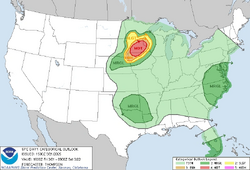 The Storm Prediction Center's MODERATE risk on March 21, 2025 | |
| Meteorological history | |
|---|---|
| Duration | March 21-22, 2025 |
| Tornado outbreak | |
| Tornadoes | 78 |
| Maximum rating | EF5 tornado |
| Duration | 21 hours, 46 minutes |
|
| |
| Highest winds | Tornadic - 315 mph (507 km/h) (Southern Minnesota EF5 on March 21) |
| Overall effects | |
| Fatalities | 267 |
| Injuries | 2,186 |
| Damage | $7.38 billion (2025 USD) |
| Areas affected | South Central Minnesota and North Central Iowa |
| Power Outages | ~1,000,000 |
|
| |
| Part of the Tornadoes of 2025 | |
***WIP***
The Tornado Outbreak of March 21-22, 2025 was one of the deadliest and most destructive tornado events in recent U.S. history. This outbreak was responsible for 78 tornadoes, including two devastating EF5 tornadoes, over the course of 21 hours and 46 minutes. The outbreak primarily impacted southern Minnesota and north-central Iowa, but its effects were felt across several neighboring states.
With over 267 fatalities and 2,186 injuries, this event is remembered as the deadliest tornado outbreak since the 2011 Super Outbreak. The scale of the destruction was staggering, with over $7.38 billion USD in damage, making it one of the costliest natural disasters in U.S. history. The two EF5 tornadoes, including the notorious Southern Minnesota EF5, were responsible for the majority of the damage and loss of life.
This event also marked the first occurrence of an EF5 tornado since the May 20, 2013 Moore, Oklahoma, tornado with it being nearly 12 years. This event became the first to use the newly revamped Enhanced Fujita Scale which now included wind speed measurements. The rapid intensification and nighttime nature of many of the tornadoes made this outbreak particularly dangerous.
National Weather Service Response
In an unprecedented and critical decision, the National Weather Service (NWS) office in Chanhassen, Minnesota, changed its emergency alert voice back to the well-known Tom after the devastating impact of the Mankato EF5 tornado. This switch was made in an attempt to get more residents to heed the warnings, as the iconic voice had been used for many years and was believed to instill a heightened sense of urgency.
This change followed previous weather incidents earlier in the week, where straight-line wind damage had been reported near Mankato. Despite this, most residents were unprepared for the scale of destruction that the outbreak would bring. Concerns over additional nighttime tornadoes grew, especially as the storms strengthened in the evening hours.
The NWS’s efforts, combined with local emergency management, included the mobilization of storm spotters, media alerts, and frequent tornado emergency declarations as the outbreak unfolded. Local TV and radio stations also ramped up coverage, with live footage of the Southern Minnesota EF5 tornado as it approached major population centers.
Meteorological synopsis
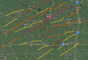
(EF2 is Yellow / EF3 is Orange / EF4 is Red / EF5 is Pink)
While Minnesota and Iowa were hardest hit, the larger weather pattern affecting the Upper Midwest was influenced by a potent La Niña event, which had dominated the winter of 2024-2025. A polar jet stream descended far south into the continental U.S., bringing with it cold air from the Canadian Rockies. This cold air collided with the unusually warm, moisture-laden air streaming northward from the Gulf of Mexico. The convergence of these two powerful air masses created an environment ripe for tornadic development.
Meteorologists had been closely monitoring the situation days in advance. On March 20, 2025, a deep low-pressure system began moving southeast from Alberta and Saskatchewan. As this system intensified, it tapped into warm, unstable air, leading to significant convective energy across the Upper Midwest. By the early morning hours of March 21, meteorologists at the Storm Prediction Center (SPC) in Norman, Oklahoma issued a moderate risk for severe weather, warning of the potential for large, long-track tornadoes.
As the system progressed into southern Minnesota and northern Iowa, CAPE values between 5000-7000 J/kg combined with deep-layer shear exceeding 60 knots, creating a highly favorable environment for tornadic supercells. The surface dew points climbed into the upper 60s and low 70s, making the air particularly unstable. The presence of a dryline extending into Nebraska further enhanced the risk of severe weather, with thunderstorms expected to erupt as the afternoon progressed.
Morning Tornadoes and Initial Development
The first tornado of the day touched down near Mankato, Minnesota at approximately 1:54 PM CDT. This tornado rapidly intensified, reaching EF5 strength with winds estimated at 210 mph (340 km/h). The Mankato EF5 became one of the most notable tornadoes of the day, causing widespread destruction in and around the city. Several homes and businesses were leveled, and power outages stretched for miles. Despite the widespread devastation, quick warnings and effective emergency response likely saved many lives during this early portion of the outbreak.
However, the Mankato EF5 was only the beginning. As the afternoon progressed, more tornadoes touched down, with several notable events occurring across southern Minnesota. Storm chasers reported large wedge tornadoes, some over a mile wide, with intense inflow and rapidly rotating wall clouds. The following tornadoes caused significant damage:
- Vernon Center EF4: This tornado caused catastrophic damage in the small town of Vernon Center, obliterating several homes and uprooting lots of trees. Wind speeds were estimated at 185 mph (298 km/h).
- Minnesota Lake EF3: The Minnesota Lake EF3 produced severe damage, particularly in rural areas, with numerous farmsteads destroyed. It was notable for producing large hailstones, some over 4 inches in diameter.
- Waseca-Owatonna EF3: This tornado carved a path across rural areas before striking the outskirts of Waseca and Owatonna, leveling barns and causing significant tree damage.
- St. Clair-Janesville EF2: This tornado remained on the ground for 15 miles, causing moderate to severe damage in its path. Several homes and outbuildings were destroyed, though fatalities were minimal due to effective warnings.
Evening Escalation and Southern Minnesota EF5
As daylight faded, concerns over more violent tornadoes began to rise. Atmospheric conditions became even more conducive to severe weather, with helicity values reaching as high as 800 m²/s². Meteorologists were particularly alarmed by the increasing wind shear, which suggested the potential for longer-lived, stronger tornadoes, including the possibility of additional EF4 or EF5 events.
After sunset, the atmosphere remained highly volatile, and a second round of storms began to fire, marking the beginning of what would be known as the Minnesota Superstorm. The first significant tornado of the night, the Windom-Hanska EF3, set the stage for the evening’s extreme weather. Shortly thereafter, the Jackson EF3 tornado formed, initiating a deadly series of nighttime tornadoes.
The second EF5 tornado of the day, the Southern Minnesota EF5, touched down near South Branch around 8:50 PM CDT. This tornado rapidly intensified, quickly reaching EF4 and eventually EF5 intensity. Mobile Doppler radar estimated wind speeds of up to 315 mph (507 km/h), the strongest recorded during the outbreak.
As the tornado moved northeast, it tore through the towns of Garden City, Rapidan, Madison Lake, and Kilkenny, obliterating everything in its path. Mankato was struck for a second time, with catastrophic results. The tornado’s peak winds reached 315 mph (507 km/h) as it devastated much of the city, including college dormitories at Minnesota State University (MSU). The tornado maintained its EF5 strength for much of its path, leaving behind near-total destruction.
Significant tornadoes from the evening included:
- New Ulm EF4
- Mapleton-Pemberton EF4
- Brush Creek-Wells EF4
- Faribault EF3
- Cleveland-Le Center EF3
- St. Peter EF3
- Elmore-Frost EF2
- Comfrey EF2
Confirmed tornadoes
| EFU | EF0 | EF1 | EF2 | EF3 | EF4 | EF5 | Total |
|---|---|---|---|---|---|---|---|
| 0 | 31 | 19 | 14 | 8 | 4 | 2 | 78 |
Minnesota Lake, Minnesota
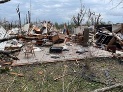 A home in downtown Minnesota Lake suffering high-end EF3 damage. | |
| Meteorological history | |
|---|---|
| Formed | March 21st, 2021, 4:14 p.m. CDT (UTC-5:00) |
| Dissipated | March 21st, 2021, 5:08 p.m. CDT (UTC-5:00) |
| Duration | 54 minutes |
| EF3 tornado | |
| on the Enhanced Fujita scale | |
| Highest winds | 165 mph (266 km/h) |
| Overall effects | |
| Fatalities | 9 |
| Injuries | 77 |
Main Article: 2025 Minnesota Lake tornado
The 2025 Minnesota Lake tornado was a strong and photogenic EF3 tornado that struck the town of Minnesota Lake on March 21st, 2025. While considered one of the lesser intense tornadoes in this devastating outbreak, it still caused significant destruction and left a lasting impact on the community. The tornado formed to the northwest of Delavan at 4:14 p.m. CDT as a small, weak vortex. At this early stage, it caused only low-end EF1 damage as it moved over sparsely populated farmland, hitting a few farmsteads and rural homes.
However, as the tornado tracked southeast toward Minnesota Lake, it rapidly intensified. Doppler radar data recorded wind speeds of 175 mph (282 km/h) as the tornado crossed Lake Minnesota, a strength consistent with a low-end EF4 tornado. Fortunately, at this time, the tornado was mostly over open water, sparing any significant structures from taking direct hits. This period of the tornado’s lifecycle was notable for its dramatic, wide funnel cloud and intense inflow, which storm chasers documented as the tornado passed over the lake.
Upon reaching Minnesota Lake, the tornado grew wider than the town itself, impacting nearly every home and business in its path. The tornado made a direct hit on downtown Minnesota Lake, where it caused its most significant damage. Doppler radar continued to show wind speeds close to 175 mph (282 km/h), though the damage on the ground was rated as high-end EF3 intensity, with the most severe damage occurring in the town’s central business district. Many homes were completely destroyed or severely damaged, with their roofs torn off and walls collapsed. However, structural assessments determined that none of the buildings hit directly were well-constructed enough to warrant an EF4 rating, despite the radar-measured wind speeds.
There were at least two areas of town where survey teams heavily debated upgrading the damage rating to EF4, particularly near Central Farm Service and along 411 Water Street, where a semi-truck parked along State Highway 22 was picked up and thrown, resulting in an explosion that engulfed several nearby structures in flames. The damage in this area was catastrophic, but much of it was exacerbated by fires caused by the explosion. As a result, the official damage rating remained at EF3, due to the lack of conclusive evidence supporting EF4 wind speeds outside of the radar data.
The entirety of Minnesota Lake felt the effects of the tornado’s powerful wind field, with even the far northern edges of the town experiencing low-end EF1 damage. Many homes were left with only minor roof and window damage in these outer regions. Power lines were downed across the town, leaving the community without electricity for several days following the storm. Emergency response teams had difficulty accessing some of the worst-hit areas due to fallen trees and debris blocking roadways.
As the tornado exited Minnesota Lake and continued its path eastward, it began to lose intensity. The worst damage was confined to the town itself, and as the tornado moved into more rural areas, it only produced high-end EF1 to low-end EF2 damage to several farmsteads and rural properties. A handful of barns and outbuildings were destroyed, and there was widespread tree damage, but fortunately, no further casualties were reported. The tornado finally began to weaken as it crossed the Cobb River, and by 5:08 p.m. CDT, it had roped out and dissipated to the north of Possin Dairy Farm.
The destruction in Minnesota Lake was widespread, with an estimated 70% of the town’s buildings suffering damage, and many being completely destroyed. The recovery process was slow, as much of the infrastructure, including roads, utilities, and public services, had been severely compromised. FEMA and local emergency responders set up temporary shelters and provided aid to the hundreds of residents left homeless by the tornado. The town was under a state of emergency for over a week, and recovery efforts were expected to take several months.
While the tornado claimed the lives of 9 people and injured nearly 279 others, the swift issuance of warnings and the quick response of local authorities were credited with preventing a higher death toll. Many residents had taken shelter in basements or interior rooms of their homes, which likely saved lives, particularly in the downtown area.
The 2025 Minnesota Lake tornado will be remembered for the devastation it caused in a small but tightly-knit community. Its photogenic nature, combined with its rapid intensification and direct hit on the town, made it one of the more well-documented tornadoes of the outbreak. However, despite radar data suggesting stronger winds, the official rating remained at EF3, marking it as a reminder of the destructive power of even "moderate" tornadoes.
North Mankato-Mankato, Minnesota
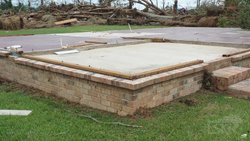 A well-built home suffering EF5 damage on Roe Crest Drive in North Mankato. | |
| Meteorological history | |
|---|---|
| Formed | March 21st, 2021, 1:54 p.m. CDT (UTC-5:00) |
| Dissipated | March 21st, 2021, 2:36 p.m. CDT (UTC-5:00) |
| Duration | 42 minutes |
| EF5 tornado | |
| on the Enhanced Fujita scale | |
| Highest winds | 210 mph (340 km/h) |
| Overall effects | |
| Fatalities | 37 |
| Injuries | 398 |
Main Article: 2025 Mankato tornado
The tornado that struck Mankato and North Mankato during the early afternoon of March 21, 2025, was one of the most destructive tornadoes in Minnesota’s history. As the first of two EF5 tornadoes during the outbreak, it produced widespread devastation and inflicted the highest death toll of any tornado during the outbreak.
The tornado began as a small, narrow vortex along U.S. Highway 169, rapidly intensifying as it tracked ENE at a forward speed of 20 mph. Within minutes, the storm transformed into a massive, dark wedge, growing in size and strength as it barreled towards the densely populated suburbs of North Mankato.
By the time the tornado reached Roe Crest Drive and Lookout Drive in North Mankato, it had reached its peak intensity, with estimated wind speeds of 210 mph (340 km/h). The destruction in this area was catastrophic, with entire neighborhoods wiped out. Survey teams noted that homes were completely swept off their foundations, with many anchor bolts either sheared off or bent, a clear indication of EF5 wind speeds. One of the most iconic images from the aftermath showed a well-built home completely disintegrated, leaving only a bare foundation.
Several businesses and industrial buildings along Belgrade Avenue were also completely destroyed, including several auto shops and small businesses that were either obliterated or reduced to twisted piles of metal and debris. Despite the total destruction, many residents had evacuated to underground shelters, which helped mitigate the number of fatalities in the area.
The tornado’s massive wind field also impacted infrastructure, tearing down power lines and snapping large steel transmission towers like matchsticks. North Mankato experienced complete power outages that lasted for several days after the event.
As the tornado continued its path eastward, it crossed the Minnesota River and tore into downtown Mankato, an area with a higher concentration of buildings and population. Survey teams reported that the tornado lost none of its momentum after crossing the river—in fact, it seemed to intensify.
In downtown Mankato, the tornado flattened multiple homes and businesses, producing high-end EF4 damage over a wide area. Several structures were completely obliterated, leaving nothing but debris scattered across streets. Among the hardest-hit areas were local bars and restaurants, many of which were reduced to only a few walls. One home near Front Street was officially rated EF5, with only the foundation remaining and debris scattered far downwind. This was the first official EF5 rating of the day.
The sheer scale of destruction in downtown Mankato was overwhelming. Several apartment buildings sustained significant damage, with windows blown out and walls partially collapsed. Hospitals and emergency services were immediately inundated with injured residents, as nearly 400 people sustained injuries during the tornado’s rampage.
After leveling much of downtown, the tornado continued to gain strength as it approached Madison Avenue, the commercial heart of Mankato. As the tornado moved uphill along Madison Avenue, its forward speed increased to 25 mph, allowing it to cut a swath of destruction through commercial areas with little resistance.
Several major businesses along Madison Avenue were either completely leveled or suffered significant structural damage. Survey teams identified several banks that were reduced to piles of rubble, while a nearby gas station exploded after being struck by debris, causing fires that further complicated rescue efforts. The fire at the gas station spread to adjacent buildings, resulting in additional damage beyond what the winds had already caused.
Perhaps the most notable near-miss of the day occurred when the tornado narrowly missed the River Hills Mall, the largest shopping center in Mankato. Although the center of the mall was spared, parts of the exterior suffered low-end EF4 damage, with several storefronts destroyed and vehicles tossed across the parking lot. The tornado also struck the nearby Wow Zone entertainment center, which sustained high-end EF4 damage. This portion of the tornado’s path caused some of the highest commercial losses of the day.
As the tornado continued northeast, it began to weaken, though it still produced EF2-EF3 damage as it tore through the industrial and commercial areas east of River Hills Mall. Several auto dealerships and repair shops were completely destroyed, with cars tossed hundreds of yards. The tornado began to occlude and weaken just north of Marsh Street, finally dissipating at 2:36 p.m. CDT, northeast of town.
While the tornado had weakened by the time it left the Mankato area, the damage it left behind was immense. Over 37 fatalities were recorded, and nearly 398 people were injured, many critically. Emergency services were overwhelmed, and several hospitals had to activate emergency triage stations to handle the influx of injured residents.
The aftermath of the tornado was one of the most significant in Mankato’s history. Entire neighborhoods in both North Mankato and downtown Mankato were left in ruins, with emergency responders struggling to navigate the debris-strewn streets. Power lines were down across the city, leaving much of Mankato without electricity for days. Thousands of residents were displaced from their homes, with local schools, churches, and public buildings being converted into makeshift shelters.
The National Guard was called in to assist with search-and-rescue operations, particularly in the hardest-hit areas near Madison Avenue and downtown. Helicopters were used to survey the damage from above, while local authorities went door to door, checking for survivors trapped in the rubble. The destruction in downtown Mankato was so extensive that many streets had to be completely rebuilt, and rebuilding efforts were expected to take months, if not years.
The tornado’s path through Mankato provided valuable insights into structural resilience and the effectiveness of modern building codes. Many of the homes in North Mankato were older and did not meet current tornado-resilient building standards, which contributed to the widespread destruction and loss of life. In contrast, newer commercial buildings along Madison Avenue fared slightly better, though even they were no match for the EF5 winds.
Anchor bolts in several homes were found either completely sheared off or bent beyond recognition, a testament to the tornado’s incredible power. This led structural engineers to call for stricter building codes and more widespread adoption of tornado shelters in residential areas, particularly in regions prone to severe weather.
The Mankato EF5 tornado left an indelible mark on the region. In the years following the disaster, the event became a case study for meteorologists, engineers, and emergency management professionals, who analyzed both the storm’s behavior and the community’s response. The lessons learned from the 2025 Mankato tornado helped inform future severe weather preparedness efforts in Minnesota and beyond.
In addition, memorials were established in both North Mankato and downtown Mankato to honor the victims and first responders. Each year, the community gathers to remember those lost and to reflect on the resilience and recovery that followed in the wake of the storm.
South Branch-Lewisville-Garden City-Rapidan-Mankato-Madison Lake-Kilkenny, Minnesota
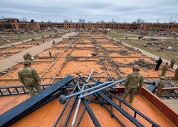 EF5 damage inflicted to the MSU college campus. | |
| Meteorological history | |
|---|---|
| Formed | March 21st, 2025, 8:50 p.m. CDT (UTC-5:00) |
| Dissipated | March 21st, 2025, 10:06 p.m. CDT (UTC-5:00) |
| Duration | 1 hour, 16 minutes |
| EF5 tornado | |
| on the Enhanced Fujita scale | |
| Highest winds | 315 mph (507 km/h) |
| Overall effects | |
| Fatalities | 221 |
| Injuries | 1,711 |
Main Article: 2025 Southern Minnesota tornado
The Southern Minnesota EF5 tornado was the most dominant and destructive tornado of the March 21–22, 2025 tornado outbreak. It remains the costliest tornado in U.S. history, surpassing even the devastating 2011 Joplin tornado in economic loss and severity. The tornado developed at 8:50 PM CDT southwest of South Branch, Minnesota, as a violent supercell intensified within an extremely volatile atmosphere marked by extreme instability and powerful wind shear.
Shortly after touching down, the tornado rapidly grew into a massive 2-mile-wide wedge tornado as it approached Lewisville and Garden City. Ground surveys conducted by the National Weather Service (NWS) and the Structural Extreme Wind Task Force (SWTF) reported that the tornado carved 2–3-foot-deep trenches into the soil over farmland—a phenomenon rarely seen, even in the most violent tornadoes. The last time extreme ground scouring was evident was during the 2011 Super Outbreak in Philadelphia MS. This was a forewarning of the catastrophic damage to come.
In Garden City, entire neighborhoods were swept clean to their foundations. Homes with steel-reinforced, anchor-bolted foundations were torn apart, leaving bare concrete slabs. Massive trees were de-barked and shredded, with only stumps remaining in some cases. Vehicles were lofted hundreds of yards and found wrapped around utility poles or mangled into unrecognizable debris. The tornado scraped the northern edge of town, but still showed no mercy to the neighborhoods in came into contact with. By the time the tornado did reach Garden City, it was estimated to be near the intensity that is was in the next upcoming location. Rapidan.
As the tornado reached the Rapidan Dam, a Doppler on Wheels (DOW) unit recorded wind speeds of 288 mph. The dam suffered catastrophic failure, unleashing torrents of water into the Blue Earth River valley and flooding downstream communities, including parts of Mankato. Engineers described the damage to the dam as “unprecedented,” with massive chunks of concrete scoured away and support structures obliterated by the combined force of wind and debris impacts. The town of Rapidan itself was spared, but the neighborhoods near and around the dam which were still uninhabitable ever since the dam failure in early 2024. This meant that the tornado did not claim any lives nor injuries here, but the damage was still one of the most intense areas of tornado damage ever documented.
Approaching Mankato, the tornado reached its peak intensity. At Minnesota State University, Mankato, a DOW unit measured winds at an extraordinary 342 mph, among the strongest winds ever recorded in a tornado globally. However, after damage surveys, experts determined a median wind speed of 315 mph to represent the tornado’s peak intensity—still placing it firmly at the EF5 classification. This was a historic feet none the less, and the damage here would definitely place this tornado in the conversation as being one of the strongest tornadoes on planet Earth.
Destruction in Mankato reached apocalyptic proportions. The tornado scoured 2–3-foot-deep trenches into the ground as it carved through neighborhoods, stripping away topsoil and pavement entirely. Homes were pulverized into splinters, debris was thrown several miles, and entire subdivisions were obliterated, leaving survivors unable to identify where streets once stood. Vehicles were thrown through buildings, and storm shelters were compromised, with doors ripped off hinges and concrete structures showing stress fractures.
The tornado laid waste to the city’s commercial district along Madison Avenue, where large retail stores, office buildings, and industrial warehouses were reduced to rubble. Damage in this corridor alone exceeded $1.6 billion. At the university, multiple dormitories were swept away, and the science and engineering buildings were obliterated. Cars from campus parking lots were found up to a mile away, with some embedded into the sides of homes.
The Blue Earth County Emergency Operations Center sustained a direct hit and collapsed, severely hampering rescue and recovery efforts. Emergency responders described the city as a “war zone,” with infrastructure flattened, streets impassable, and survivors trapped beneath debris.
The tornado continued its devastation into Madison Lake, destroying lakefront homes and sweeping structures into the water. The community of Kilkenny suffered catastrophic losses to farmsteads, where livestock was found miles away, and fields were left completely barren as the tornado stripped away the topsoil. The tornado finally dissipated west of Shieldsville at 10:06 PM CDT, after carving a 66-mile path of destruction over the course of 1 hour and 16 minutes.
In the aftermath, the scope of the devastation became clear. The tornado claimed 221 lives, injured 1,711 people, and caused a record-setting $4.5 billion in damage. Over 22,000 structures were damaged or destroyed, including 8,000 homes swept completely away. Damage declarations were issued for four counties—Watonwan, Blue Earth, Le Sueur, and Rice—and Minnesota Governor Tim Walz promptly declared a state of emergency, mobilizing National Guard units to assist overwhelmed local authorities.
This tornado was the most dominant of the outbreak, dwarfing others in scale, intensity, and destruction. Its historic wind speeds, unparalleled damage path, and catastrophic impact on infrastructure—combined with the secondary disaster caused by the Rapidan Dam failure—make this event a benchmark in meteorological and disaster history. The sheer violence of this tornado, from the trenches carved into farmland to the obliteration of entire communities, solidified its legacy as one of the most violent tornadoes ever recorded.
Impact and Aftermath
In the immediate aftermath, local and state authorities declared a state of emergency. The National Guard was called in to assist with search-and-rescue operations. The damage in Mankato and surrounding areas was so extensive that many neighborhoods were unrecognizable, with streets clogged by debris and homes reduced to rubble.
Rescue teams worked through the night, using thermal imaging cameras, search dogs, and other tools to locate survivors trapped beneath the debris. In some cases, survivors were pulled from basements where they had sought shelter from the storm. Despite the swift response, many areas were inaccessible for hours, delaying rescue efforts.
The tornadoes had a profound impact on regional infrastructure. Widespread power outages affected over 1 million people across southern Minnesota and northern Iowa. Numerous substations were destroyed, and many areas remained without power for days as utility crews struggled to assess and repair the damage. Communication systems were also disrupted, with cell towers down and radio communications hampered by power loss. In some areas, it took several days for emergency services to restore basic communication.
In the immediate aftermath, local and state authorities declared a state of emergency. The National Guard was called in to assist with search-and-rescue operations. The damage in Mankato and surrounding areas was so extensive that many neighborhoods were unrecognizable, with streets clogged by debris and homes reduced to rubble.
Rescue teams worked through the night, using thermal imaging cameras, search dogs, and other tools to locate survivors trapped beneath the debris. In some cases, survivors were pulled from basements where they had sought shelter from the storm. Despite the swift response, many areas were inaccessible for hours, delaying rescue efforts.
The March 21-22, 2025 outbreak drew numerous comparisons to previous significant tornado events, including the 2011 Super Outbreak and the 1999 Oklahoma Tornado Outbreak. The scale of destruction, particularly in Mankato, was compared to the damage seen in Joplin, Missouri in 2011.
The Southern Minnesota EF5 also became one of the strongest tornadoes ever recorded, with peak wind speeds of 315 mph (507 km/h), putting it in the same category as some of the most violent tornadoes in U.S. history, including the 1999 Bridge Creek-Moore F5. Even though Doppler radar measured wind speeds of 342 mph (550 km/h), the NWS in Chanhassen rated the damage with a median rating between 288–342 mph (463–550 km/h) which was 315 mph (507 km/h). With the highest wind speed measurements, this tornado surpassed the 1999 Bridge Creek-Moore F5 and the 2013 El Reno EF3.
