2025 Southern Minnesota tornado
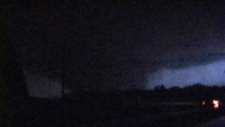
 The tornado as it approached Minnesota State University in Mankato. | |
| Meteorological history | |
|---|---|
| Formed | March 21, 2025, 8:50 p.m. CDT (UTC-5:00) |
| Dissipated | March 21, 2025, 10:06 p.m. CDT (UTC-5:00) |
| Duration | 1 hour, 16 minutes |
| EF5 tornado | |
| on the Enhanced Fujita scale | |
| Max width | 2,235 yards (1.27 mi; 2.04 km) |
| Path length | 66.86 miles (107.60 km) |
| Highest winds | 315 mph (507 km/h) (Unofficial Intensity: 342 mph (550 km/h) as per mobile Doppler radar) |
| Overall effects | |
| Fatalities | 221 (+8 indirect) |
| Injuries | 1,711 |
| Damage | $4.5 billion (2025 USD) |
| Areas affected | Watonwan, Blue Earth, Le Sueur, and Rice counties in Minnesota |
|
| |
| Part of the Tornado outbreak of March 21-22, 2025 and Tornadoes of 2025 | |
The 2025 Southern Minnesota Tornado was one of the most catastrophic and violent tornadoes in United States history. Developing under a rare convergence of extreme meteorological conditions on the evening of March 21st, 2025, the tornado touched down southwest of South Branch, Minnesota and quickly intensified. Reaching EF5 strength within minutes, the tornado grew to a maximum width of 2.1 miles and maintained its violent intensity for much of its 66-mile path. The tornado’s peak wind speed of 342 mph (550 km/h) near Mankato is among the strongest ever recorded by mobile Doppler radar. Official wind speeds were recorded at 315 mph (507 km/h) after averaging between 342 mph (550 km/h) and 288 mph (463 km/h).
The tornado’s destructive path swept through multiple communities, leaving behind unprecedented levels of devastation. The city of Mankato, including Minnesota State University, bore the brunt of the tornado at peak strength. Thousands of homes, businesses, and critical infrastructure were destroyed, with entire neighborhoods flattened. The collapse of the Rapidan Dam near Rapidan exacerbated the disaster by triggering widespread flooding in downstream areas, compounding both the human and economic toll.
In total, the tornado caused 221 fatalities, injured over 1,700 people, and resulted in $4.5 billion in damages. It remains the single costliest tornado on record, surpassing the 2011 Joplin tornado. The event underscored vulnerabilities in tornado preparedness, particularly for nocturnal storms, and reshaped emergency response strategies nationwide.
Meteorological synopsis

The Southern Minnesota EF5 tornado occurred under a set of historically rare and extreme meteorological conditions that supported the development of violent, long-lived tornadoes across the Upper Midwest. These conditions included record-setting instability, exceptional wind shear, and a powerful upper-level trough.
- Upper-Level Trough and Jet Dynamics: A deep, negatively tilted trough entered the Central United States on March 21st, enhancing widespread lift and organizing a strong 120-knot jet streak in the mid-levels of the atmosphere. The jet streak's orientation aligned favorably with surface wind shear, creating ideal conditions for tornadogenesis.
- Surface Low and Warm Sector: A deep surface low-pressure system (985 mb) tracked across the Dakotas into Minnesota, pulling moisture-rich Gulf air northward into the region. Dew points surged into the upper 60s°F, an unprecedented anomaly for March in Minnesota.
- Record Instability: Convective Available Potential Energy (CAPE) values soared between 4,000–7,000 J/kg in portions of southern Minnesota, a level of atmospheric instability rarely observed this far north. Combined with steep mid-level lapse rates, storms rapidly became explosively strong supercells.
- Wind Shear and Helicity: Low-level wind shear exceeded 500 m²/s², with storm-relative helicity peaking at 800 m²/s². This extreme helicity allowed for rapid vertical updraft rotation, supporting the tornado's formation and long-term sustainability.
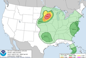
- Dryline Trigger Mechanism: A sharp dryline draped across Iowa and Minnesota provided the initiation point for supercell development during the late afternoon and evening hours of March 21st. By nighttime, a cluster of intense supercells formed, one of which produced the catastrophic EF5 tornado.
- Tornado Outbreak Context: The Southern Minnesota tornado was one of seventy-eight tornadoes, including two EF5s, produced by the March 21–22 outbreak. This outbreak ranks as one of the most intense tornado events on record, stretching from Iowa to Minnesota.
Tornado Summary

The tornado first touched down southwest of South Branch, Minnesota, at approximately 8:50 PM CDT. Within moments, the storm intensified to EF4 strength, demolishing farmsteads and small rural communities. As it advanced northeast, the tornado expanded rapidly, growing to a width of 2.1 miles as it struck the town of Rapidan.
Rapidan
The tornado’s winds reached 288 mph (463 km/h) near Rapidan, causing catastrophic damage to homes, infrastructure, and the Rapidan Dam. The dam’s collapse unleashed a torrent of floodwaters into the Blue Earth River, devastating downstream neighborhoods and further complicating rescue efforts.
Mankato
The tornado reached its peak intensity of 342 mph (550 km/h) as it entered Mankato, directly impacting Minnesota State University. Entire dormitories and academic buildings were reduced to rubble, with some structures swept completely from their foundations. The university’s football stadium was obliterated, with steel beams bent and tossed hundreds of yards. Commercial areas, including River Hills Mall and the Walmart Supercenter, were flattened, while residential neighborhoods saw near-total destruction.

Madison Lake
As the tornado moved eastward, it struck the town of Madison Lake. Homes along the northwest shoreline were scoured from their foundations, and large sections of forest were leveled.
Kilkenny and Shieldsville
The tornado began to weaken as it approached Kilkenny and Shieldsville but still produced EF2 damage, with significant destruction to farmsteads and rural structures. The storm finally dissipated at 10:06 PM CDT, ending its 66-mile path of devastation.
Aftermath and Legacy
The scale of destruction across southern Minnesota overwhelmed local emergency response systems. The collapse of the Rapidan Dam compounded the crisis, as floodwaters engulfed portions of Mankato and nearby communities, leaving thousands stranded.
- Search and Rescue: Over 2,000 first responders and National Guard troops were deployed to assist with search and rescue operations. Helicopters and boats were used to reach isolated survivors in flooded areas.
- Fatalities and Injuries: The tornado caused 221 direct deaths, with many victims found in collapsed homes or vehicles. An additional 8 indirect deaths occurred due to flooding, power outages, and rescue-related incidents.
- Economic Impact: The tornado caused $4.5 billion in damages, destroying over 15,000 structures and leaving tens of thousands homeless.
- Federal Response: The Governor of Minnesota declared a state of emergency, and federal disaster relief efforts were expedited. The event prompted FEMA to issue an immediate response plan for large-scale tornado impacts.
The 2025 Southern Minnesota tornado remains a benchmark in severe weather history, demonstrating the destructive power of EF5 tornadoes and the vulnerabilities of modern infrastructure and preparedness systems. Its impact reshaped emergency management protocols across the United States and led to significant improvements in tornado warning dissemination, especially in nocturnal events. The tornado’s legacy also includes major investments in flood control infrastructure, spurred by the catastrophic collapse of the Rapidan Dam.
